Category:Maps of North West municipalities with 2011 borders
Jump to navigation
Jump to search
This category contains maps of municipalities in the North West province of South Africa that show the the municipal borders as they were after the municipal election of 18 May 2011. The borders of many municipalities across the country changed again in 2016.
Media in category "Maps of North West municipalities with 2011 borders"
The following 31 files are in this category, out of 31 total.
-
 Map of the North West with districts labelled (2011).svg 912 × 630; 354 KB
-
 Map of the North West with municipalities blank (2011).svg 912 × 630; 834 KB
-
 Blank map of the North West (2011).svg 838 × 596; 302 KB
-
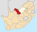
 Map of South Africa with Bojanala Platinum highlighted (2011).svg 809 × 709; 485 KB
-
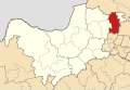
 Map of the North West with Bojanala Platinum highlighted (2011).svg 912 × 630; 295 KB
-
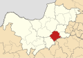
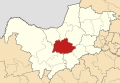
 Map of the North West with Ditsobotla highlighted (2011).svg 912 × 630; 288 KB
-
 Map of South Africa with Dr Kenneth Kaunda highlighted (2011).svg 809 × 709; 488 KB
-
 Map of the North West with Dr Kenneth Kaunda highlighted (2011).svg 912 × 630; 306 KB
-
-

-
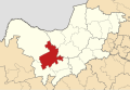
 Map of the North West with Greater Taung highlighted (2011).svg 912 × 630; 291 KB
-
 Map of the North West with Kagisano-Molopo highlighted (2011).svg 912 × 630; 304 KB
-
 Map of the North West with Kgetlengrivier highlighted (2011).svg 912 × 630; 286 KB
-
 Map of the North West with Lekwa-Teemane highlighted (2011).svg 912 × 630; 291 KB
-
 Map of the North West with Madibeng highlighted (2011).svg 912 × 630; 291 KB
-
 Map of the North West with Mafikeng highlighted (2011).svg 912 × 630; 290 KB
-
 Map of the North West with Mamusa highlighted (2011).svg 912 × 630; 288 KB
-

-
 Map of the North West with Maquassi Hills highlighted (2011).svg 912 × 630; 293 KB
-
 Map of the North West with Matlosana highlighted (2011).svg 912 × 630; 289 KB
-
 Map of the North West with Moretele highlighted (2011).svg 912 × 630; 286 KB
-
 Map of the North West with Moses Kotane highlighted (2011).svg 912 × 630; 290 KB
-
 Map of the North West with Naledi highlighted (2011).svg 912 × 630; 292 KB
-
 Map of South Africa with Ngaka Modiri Molema highlighted (2011).svg 809 × 709; 487 KB
-
 Map of the North West with Ngaka Modiri Molema highlighted (2011).svg 912 × 630; 303 KB
-
 Map of the North West with Ramotshere Moiloa highlighted (2011).svg 912 × 630; 291 KB
-
 Map of the North West with Ratlou highlighted (2011).svg 912 × 630; 291 KB
-
 Map of the North West with Rustenburg highlighted (2011).svg 912 × 630; 289 KB
-
 Map of the North West with Tlokwe highlighted (2011).svg 912 × 630; 291 KB
-
 Map of the North West with Tswaing highlighted (2011).svg 912 × 630; 289 KB
-
 Map of the North West with Ventersdorp highlighted (2011).svg 912 × 630; 286 KB
.svg)
.svg)
.svg)
.svg)
.svg)
.svg)
.svg)
.svg)
.svg)
.svg)
.svg)
.svg)
.svg)
.svg)
.svg)
.svg)
.svg)
.svg)
.svg)
.svg)
.svg)
.svg)
.svg)
.svg)
.svg)
.svg)
.svg)
.svg)
.svg)
.svg)
.svg)