English: Category for Maps of Osumi Islands in Kagoshima Prefecture, Japan
日本語: 鹿児島県・大隅諸島の地図に関するカテゴリ
<nowiki>Category:Maps of Osumi Islands; categoría de Wikimedia; kategori Wikimedia; Wikimedia category; د ويکيمېډيا وېشنيزه; Vikimedya kategorisi; ویکیمیڈیا زمرہ; kategória projektov Wikimedia; категорія проєкту Вікімедіа; 维基媒体分类; Wikimedia-Kategorie; kategorie na projektech Wikimedia; kategorija na Wikimediji; विकिपीडिया:श्रेणी; page de catégorie de Wikimedia; kategorija na Wikimediji; विकिपीडिया वर्ग; категорија на Викимедији; Wikimedia-Kategorie; Wikimedia-kategori; kategori Wikimédia; تصنيف ويكيميديا; pajenn rummata eus Wikimedia; Wikimedia:ကဏ္ဍခွဲခြင်း; 維基媒體分類; Wikimedia категориясы; categoría de Wikimedia; categoria de Wikimedia; Wikimedia-Kategorie; tudalen categori Wikimedia; kategori e Wikimedias; Վիքիմեդիայի նախագծի կատեգորիա; 维基媒体分类; Wikimedia-kategory; ვიკიპედია:კატეგორიზაცია; ウィキメディアのカテゴリ; categoria Wikimedia; تصنيف بتاع ويكيميديا; විකිමීඩියා ප්රභේද පිටුව; categoria Vicimediorum; Vikipidiya:Shopni; Wikimedia-luokka; Wikimedia-categorie; guruhi Vikimedia; катэгорыя ў праекце Вікімэдыя; Викимедиа проектындагы төркем; catigurìa di nu pruggettu Wikimedia; หน้าหมวดหมู่วิกิมีเดีย; Wikimedia:Kategorija; Wikimedia-Kategorie; Wikimedia:Klassys; категория на Уикимедия; categorie a unui proiect Wikimedia; 維基媒體分類; Wikimedia-kategori; kawan Wikimèdia; 維基媒體分類; 위키미디어 분류; Wikimedia-bólkur; kategorio en Vikimedio; kategori Wikimedia; Wikimedia:Ronnaghys; উইকিমিডিয়া বিষয়শ্রেণী; kategori Wikimedia; 维基媒体分类; וויקימעדיע קאַטעגאָריע; kategorija w projektach Wikimedije; thể loại Wikimedia; Wikimedia projekta kategorija; Wikimedia-kategorie; categoria de um projeto da Wikimedia; 维基媒体分类; категорияд Ангилал; Wikimedia-kategori; kategori Wikimedia; پۆلی ویکیمیدیا; Wikimedia category; Vikimédia ñemohenda; Wikimédia-kategória; વિકિપીડિયા શ્રેણી; Wikimediako kategoria; категория в проекте Викимедиа; Wikimedia-Kategorie; Kategoriya ning Wikimedia; Wikimedia-kategorie; Wîkîmediya:Kategorî; विकिमिडिया श्रेणी; Wikimedia-Kategorie; קטגוריה במיזמי ויקימדיה; Викимедиа проектындагы төркем; kategoria w projekcie Wikimedia; विकिमिडिया श्रेणी; 维基媒体分类; Wikimedia-kategoriija; гурӯҳи Викимедиа; Wikimedia kategooria; Wikimedia-categorie; categoría de Wikimedia; categoria di un progetto Wikimedia; Wikimedia category; 維基媒體分類; Wikimedia-Kategorie; 維基媒體分類; categurìa 'e nu pruggette Wikimedia; Viciméid catagóir; Wikimedia-kategori; Wikimedia proyektındağı törkem; ẹ̀ka Wikimedia; гурӯҳи Викимедиа; categoria de um projeto da Wikimedia; Викимедиина категорија; Wikimedia-Kategorie; tumbung Wikimedia; ردهٔ ویکیپدیا; kategorija Wikimedie; kategorya ng Wikimedia; kategoria ti Wikimedia; Викимедиа категорияһы; kategori Wikimedia; jamii ya Wikimedia; വിക്കിമീഡിയ വർഗ്ഗം; Wikimedia-categorie; kategori Wikimedia; Wikimedia category; زمرو:وڪيپيڊيا زمرا بندي; катэгорыя ў праекце Вікімедыя; categoría de Wikimedia; विकिमीडिया श्रेणी; κατηγορία εγχειρημάτων Wikimedia; விக்கிமீடியப் பகுப்பு</nowiki>
Subcategories
This category has only the following subcategory.


 Japan National Route 58 Map.png 524 × 888; 26 KB
 Japan satellite view with Yakushima tagged.png 1,557 × 1,419; 1.26 MB
 Kuchinoerabujima Relief Map, SRTM-1.jpg 800 × 600; 143 KB
 LocMap of WH Yakushima.png 369 × 398; 10 KB
 Osumi - btv1b53165314d (2 of 3).jpg 5,066 × 6,792; 3.36 MB
 Osumi - btv1b531653186 (2 of 3).jpg 8,632 × 12,684; 9.98 MB
 Osumi island ja.png 1,799 × 1,380; 729 KB
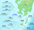 Osumi Islands Map Japan.png 1,364 × 1,188; 525 KB
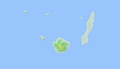 Osumi islands.PNG 2,399 × 1,379; 324 KB
 Osumi-eilanden.png 380 × 194; 13 KB
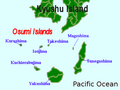 OsumiIslands.png 609 × 456; 115 KB
 Southern kyushu with adjacent islands.png 1,799 × 1,380; 720 KB
 Tanegashima location.jpg 631 × 1,120; 194 KB
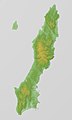 Tanegashima Relief Map, SRTM-1.jpg 600 × 1,000; 175 KB
 Tanegashima txu-oclc-6900707-nh52-8.jpg 805 × 1,730; 447 KB
 Tanegashima.png 750 × 1,700; 44 KB
 Yakushima Relief Map, SRTM.jpg 1,600 × 1,200; 864 KB
 Ōsumi Islands (大隅諸島).png 4,320 × 4,320; 13.92 MB

.jpg)
.jpg)


.png)