Category:Maps of Paris in the 1870s
Jump to navigation
Jump to search
Subcategories
This category has the following 5 subcategories, out of 5 total.
M
P
Media in category "Maps of Paris in the 1870s"
The following 111 files are in this category, out of 111 total.
-
-

-
 1870 Erhard Map of Paris and Vicinity, France - Geographicus - Paris-erhard-1870.jpg 4,000 × 3,084; 3.96 MB
-
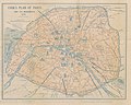
 1870 Hachette Pocket Map of Paris, France - Geographicus - NouveauParis-hachette-1870.jpg 7,000 × 5,910; 10.41 MB
-
 Paris und Umgebung 1871 cropped.jpg 1,807 × 1,677; 2.01 MB
-
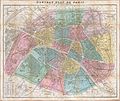
 Paris und Umgebung 1871.jpg 2,189 × 2,344; 783 KB
-
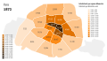 Population density of Paris, 1872 - Demographia.svg 512 × 293; 182 KB
-
 1873 – Carte pittoresques des Environs de Paris par A.Vuillemin.jpg 10,904 × 7,568; 14.18 MB
-
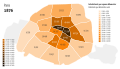 Population density of Paris, 1876 - Demographia.svg 512 × 293; 182 KB
-
 1877 Vuillemin Folding Pocket Map of Paris, France - Geographicus - Paris-vuillemin-1877.jpg 5,962 × 4,136; 8.85 MB
-
 1878 Andriveau-Goujon Pocket Map of Paris, France - Geographicus - Paris-andriveau-1878.jpg 6,000 × 4,532; 8.79 MB
-
 1878 Logerot Map of Paris, France - Geographicus - Paris-logerot-1878.jpg 6,000 × 4,099; 7.61 MB
-

-
 23 of 'Journal of the Siege of Paris ... With a map' (11093875796).jpg 4,728 × 3,880; 5.3 MB
-

-
 Adolf Stieler, Paris und Umgebung, 1873 - David Rumsey.jpg 3,031 × 2,773; 5.75 MB
-
 Adolf Stieler, Paris und Umgebung, 1875 - David Rumsey.jpg 3,590 × 3,283; 8.35 MB
-

-

-

-
-
-
 Alexandre Vuillemin, Plan de Paris, 1878 - Gallica.jpg 10,045 × 8,496; 18.7 MB
-
 Andriveau-Goujon, Environs de Paris dans un rayon de 30 kilomètres, 1876.jpg 22,109 × 17,106; 130.97 MB
-
 Auguste Logerot, Environs de Paris, 1876 - David Rumsey.jpg 13,254 × 10,043; 61.36 MB
-
 Auguste Logerot, Nouveau plan de Paris divise en 20 arrondissements, 1871.jpg 22,232 × 15,550; 135.15 MB
-
 Auguste Logerot, Nouveau plan de Paris divisée en 20 arrondissements, 1876 - David Rumsey.jpg 13,650 × 9,450; 87.98 MB
-

-

-
 Bradshaw's plan of Paris - with the latest improvements, 1874 - UWM Libraries.jpg 8,041 × 5,623; 9.77 MB
-
 Ca. 1870 map of Paris by Eugene Deschamps.jpg 36,607 × 26,981; 230.44 MB
-
 Carte du département de la Seine - 1875.jpg 10,056 × 7,569; 19.7 MB
-
 Carte statistique des égouts de Paris, égouts collecteurs par bassins en 1878 - BHVP.jpg 7,878 × 6,158; 8.97 MB
-

-
 Colton, The Environs of Paris, 1874 - David Rumsey.jpg 6,135 × 4,932; 11.34 MB
-
 Commune de Paris 1871 - Second siège de Paris 2 avril au 21 mai 1871 - Gallica.jpg 9,307 × 8,222; 12.36 MB
-
 Defense of Paris - Cornell University Library.tif 3,747 × 4,825; 51.75 MB
-
 Defense of Paris, October 1870 - Cornell University Library.tif 2,959 × 3,989; 33.79 MB
-
 Die Festungswerke von Paris 01.jpg 6,436 × 5,118; 7.51 MB
-
 Die Festungswerke von Paris 02.jpg 6,502 × 5,103; 6.38 MB
-
 Département de la Seine by Dépôt de la guerre, 1878 - Stanford Libraries.jpg 12,007 × 9,607; 21.05 MB
-
 Département de la Seine by Dépôt de la guerre, 1878 - Stanford Libraries.tif 12,007 × 9,607; 110.01 MB
-
 E.D. Vorzet, Paris et ses environs, 1874.jpg 4,483 × 3,345; 3.91 MB
-
 Eduard Dumas-Vorzet, Paris et ses environs, 1878 - Library of Congress.tiff 15,705 × 11,378; 511.27 MB
-
 Eduard Dumas-Vorzet, Paris et ses environs, 1878.jpg 15,705 × 11,378; 55.92 MB
-

-
 Fullarton, French Ports & Harbours, and Plan of Paris, 1872 - David Rumsey.jpg 6,086 × 7,985; 10.53 MB
-
 Fullarton, Paris and its surrounding fortifications, 1872 - David Rumsey.jpg 4,676 × 3,760; 11.86 MB
-
 Garnier frères, Itinéraire des Omnibus et Tramways dans Paris, 1878.jpg 14,887 × 11,573; 51.34 MB
-

-
 Guide to Paris and its Exhibition, 1878. With plan of Paris - The British Library.jpg 5,580 × 4,400; 6.47 MB
-
 Géographie illustrée de la France et de ses colonies 172.jpg 1,207 × 768; 388 KB
-

-
 Illustrated map of Paris - Norman B. Leventhal Map Center.jpg 6,521 × 4,759; 5.13 MB
-
 Illustrated map of Paris - Norman B. Leventhal Map Center.tif 6,521 × 4,759; 88.81 MB
-
 Imprimerie Lemercier, Paris, 1875 - Gallica.jpg 13,211 × 9,682; 30.61 MB
-
 J. Gaultier, Le nouveau guide de l'étranger, 1878 - David Rumsey.jpg 9,454 × 7,163; 20.5 MB
-
 Justus Perthes' Specialkarte der deutschen Grenze bis Paris.jpg 7,332 × 4,698; 15.57 MB
-
 L. Wuhrer, Bois de Vincennes, ca 1875 (I) - BHVP.jpg 1,810 × 1,355; 358 KB
-
 L. Wuhrer, Bois de Vincennes, ca 1875 (II) - BHVP.jpg 1,807 × 1,279; 356 KB
-

-

-

-
 Le Paris de Napoleon III, 1870 - Stanford Libraries - Original.jpg 21,967 × 16,679; 119.7 MB
-
 Le Paris de Napoleon III, 1870 - Stanford Libraries.jpg 21,967 × 16,679; 148.5 MB
-
 Malcolm J. Brown, Tubes atmospheriques, 1870 - David Rumsey.jpg 12,986 × 7,039; 22.74 MB
-
 New map of Paris by Victor Clerot, 1867 - Princeton University Library.jpg 11,969 × 8,304; 135.09 MB
-
 New map of Paris by Victor Clerot, 1867 - Princeton University Library.png 15,749 × 10,926; 133.02 MB
-
 New map of Paris by Victor Clerot, 1867 - Princeton University Library.tif 15,749 × 10,926; 164.13 MB
-
 Nouveau plan complet illustré de la ville de Paris en 1877 by Alexandre Vuillemin - Gallica.jpg 10,666 × 7,624; 18.97 MB
-
 Nouveau plan de Paris divisé en 20 arrondissements, 1871 - UWM Libraries.jpg 14,500 × 9,862; 25.45 MB
-

-
 Nouveau plan de Paris, 1871 - UWM Libraries.jpg 10,128 × 7,932; 17.56 MB
-

-
 Paris and its vicinity by Hydrographic Office, ca. 1870 - Stanford Libraries.jpg 6,890 × 6,301; 5.32 MB
-
 Paris and its vicinity by Hydrographic Office, ca. 1870 - Stanford Libraries.tif 6,890 × 6,301; 41.43 MB
-
 Paris en 1878. Souvenir de l'Exposition universelle Plan simplifié - Gallica.jpg 9,917 × 8,388; 16.03 MB
-

-
 Paris en mai 1871, Plan indiquant les opérations de l'Armée contre l'insurrection - Paris Musées.jpg 10,930 × 7,650; 54.59 MB
-
 Paris et ses environs - 1878 LOC 2012586603.jpg 15,705 × 11,378; 29.28 MB
-
 Paris et ses environs - 1878 LOC 2012586603.tif 15,705 × 11,378; 511.24 MB
-
 Paris nouveau by Alexandre Vuillemin, 1855 - Gallica.jpg 11,259 × 8,580; 21.3 MB
-
 Paris, bastions numérotés, forts, redoutes, batteries, 1870 - Gallica.jpg 6,646 × 5,052; 6.37 MB
-
 Paris, ses monuments et ses ruines, 1870-71 - Gallica.jpg 8,070 × 6,479; 11.48 MB
-

-
 Plan de la bataille de Champigny.jpg 2,009 × 1,562; 3.07 MB
-
 Plan de la bataille du Bourget.jpg 1,000 × 685; 707 KB
-
 Plan de Paris actuel, 1879 by J. Gaultier - Stanford Libraries.jpg 12,206 × 9,745; 20.88 MB
-
 Plan de Paris actuel, 1879 by J. Gaultier - Stanford Libraries.tif 12,206 × 9,745; 113.46 MB
-
 Plan de Paris à vol d'oiseau by Georges Peltier, ca. 1920 - Princeton University Library - Original.tiff 28,213 × 21,580; 580.67 MB
-
 Plan de Paris à vol d'oiseau by Georges Peltier, ca. 1920 - Princeton University Library.png 28,059 × 21,385; 527.9 MB
-
 Plan de Paris à vol d'oiseau by Georges Peltier, ca. 1920 - Princeton University Library.tiff 28,059 × 21,385; 572.28 MB
-

-

-
 Plan von Paris und seinen festungswerken - Norman B. Leventhal Map Center.jpg 5,581 × 4,324; 4.98 MB
-
 Plan von Paris und seinen festungswerken - Norman B. Leventhal Map Center.tif 5,581 × 4,324; 69.07 MB
-

-

-
 Russell's map of Paris and fortifications - Norman B. Leventhal Map Center.jpg 6,594 × 4,684; 4.73 MB
-
 Russell's map of Paris and fortifications - Norman B. Leventhal Map Center.tif 6,594 × 4,684; 88.39 MB
-
 Répartition des inhumations des différents arrondissements dans les cimetières proposés.jpg 8,810 × 6,979; 14.61 MB
-
 Saisi sur un officier prussien fait prisonnier - Paris Musées.jpg 6,793 × 5,344; 23.32 MB
-
 Salle Gerson - Amphithéâtre de l'ancienne rue Gerson.jpg 3,968 × 2,976; 1.7 MB
-
 Salle Gerson 15.jpg 3,968 × 2,976; 1.8 MB
-
 SDUK, Composite - Western and Eastern Divisions of Paris, 1872 - David Rumsey.jpg 15,222 × 10,895; 56.42 MB
-
 SDUK, Eastern Divisions of Paris, 1872 - David Rumsey.jpg 9,106 × 10,860; 33.09 MB
-
 SDUK, Western Divisions of Paris, 1872 - David Rumsey.jpg 9,106 × 10,862; 32.01 MB
-
 Seine by Adolphe Laurent Joanne, 1870 - Stanford Libraries.jpg 5,090 × 3,925; 3.13 MB
-
 Seine by Adolphe Laurent Joanne, 1870 - Stanford Libraries.tif 5,090 × 3,925; 19.08 MB
-

-

.jpg)
.jpg)


%27_(11111261354).jpg)
.jpg)
.jpg)


_(titel_op_object),_RP-P-2018-892.jpg)


_-_BHVP.jpg)
_-_BHVP.jpg)


