Category:Maps of Paris in the 2010s
Jump to navigation
Jump to search
Media in category "Maps of Paris in the 2010s"
The following 24 files are in this category, out of 24 total.
-
 Real estate prices in Paris, 2nd quarter 2010 - La Tribune.svg 512 × 293; 120 KB
-
 Real estate prices in Paris, 4th quarter 2010 - La Tribune.svg 512 × 293; 119 KB
-
 Real estate prices in Paris, 2nd quarter 2011 - Le Figaro.svg 512 × 293; 116 KB
-
 Real estate prices in Paris, 4th quarter 2011 - Challenges.svg 512 × 293; 118 KB
-
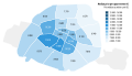
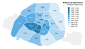
 Population density map of Paris in 2012.svg 512 × 293; 109 KB
-
 Population density of Paris, 2012 - INSEE.svg 512 × 293; 183 KB
-
 Real estate prices in Paris, 1st quarter 2012 - Huffington Post.svg 512 × 293; 118 KB
-
 Real estate prices in Paris, November 2012 - Challenges.svg 512 × 293; 117 KB
-

-

-
-
 Real estate prices in Paris, 4th quarter 2014 - Le Monde.svg 512 × 293; 118 KB
-
 Real estate prices in Paris, May 2015 - SeLoger.svg 512 × 293; 117 KB
-
 Real estate prices in Paris, November 2015 - SeLoger.svg 512 × 293; 121 KB
-
 Real estate prices in Paris, 1st quarter 2016 - Huffington Post.svg 512 × 293; 117 KB
-
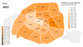 Population density of Paris, 2017 - INSEE.svg 512 × 293; 182 KB
-

-
 Real estate prices in Paris, 4th quarter 2017 - Challenges.svg 512 × 293; 117 KB
-
 Real estate prices in Paris, October 2017 - Le Parisien.svg 512 × 293; 118 KB
-
 Real estate prices in Paris, February 2018 - SeLoger.svg 512 × 293; 122 KB
-
 Real estate prices in Paris, October 2018 - SeLoger.svg 512 × 293; 118 KB
-

-
 Real estate prices in Paris, September 2019 - Le Parisien.svg 512 × 293; 118 KB
-
 Real estate prices in Paris, September 2019 - SeLoger.svg 512 × 293; 118 KB


