Category:Maps of Petra
Jump to navigation
Jump to search
Media in category "Maps of Petra"
The following 35 files are in this category, out of 35 total.
-
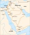
 PetraLocation.png 288 × 272; 8 KB
-
 Karta Petra.PNG 679 × 497; 33 KB
-
 PetraMap2.png 780 × 554; 128 KB
-
 1822 Burckhardt map of Wady Musa (Petra).jpg 2,598 × 3,690; 640 KB
-
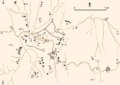
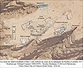
 IRBY(1823) p470 SKETCH OF THE GROUND PLAN OF PETRA.jpg 2,227 × 2,135; 2.02 MB
-

-
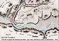
 Burckhardt map petra 1822.jpg 624 × 909; 111 KB
-
 Geolocalisation Petra Jordanie.png 1,088 × 1,197; 144 KB
-
 Irby mangles map petra 1823.jpg 739 × 716; 121 KB
-
 Karta Petra-ar.png 679 × 497; 69 KB
-
 Map of Petra.jpg 3,894 × 2,090; 3.76 MB
-
 Map.Petra.Jordania.deutsch.png 1,000 × 899; 731 KB
-
 MelacaMap-Blanco.png 780 × 554; 113 KB
-
 Metropolitan see of Petra.jpg 450 × 677; 121 KB
-
 Petra Byzantine church plan.svg 1,550 × 790; 60 KB
-
 Petra localización map-es.png 399 × 600; 373 KB
-
 Petra location map-de-2.svg 1,330 × 2,000; 1.06 MB
-
 Petra location map-de.svg 1,330 × 2,000; 1.08 MB
-
 Petra location map-es.svg 1,330 × 2,000; 1.06 MB
-
 Petra location map-fr.svg 1,330 × 2,000; 1.09 MB
-
 Petra location map-it.svg 1,330 × 2,000; 1.09 MB
-
 Petra-karte.png 886 × 700; 166 KB
-
 Petra1.png 297 × 329; 27 KB
-
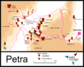
 PetraBigMapHE.png 1,500 × 1,065; 570 KB
-
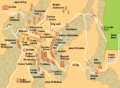
 PetraMap.png 951 × 675; 44 KB
-
 Pétra. Carte des routes commerciales du Ier siècle.png 702 × 814; 52 KB
-
 Pétra. Carte hydrologique.jpg 1,824 × 1,350; 626 KB
-
 Pétra. Les bâtiments du djebel Khubthah en 2017.jpg 2,419 × 1,971; 1.26 MB
-
 Pétra. Plan de la région des thermes de Sabra en 1830.jpg 1,529 × 1,073; 920 KB
-
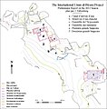
 Pétra. Plan des différentes zones de fouilles.jpg 685 × 1,071; 313 KB
-
 Pétra. Plan des thermes de Sabra.jpg 1,523 × 1,039; 841 KB
-
 Pétra. Plan des thermes du djebel Khubthah en 2012.jpg 1,824 × 2,340; 1.11 MB
-
 Pétra. Plan des thermes du Grand Temple.jpg 2,173 × 2,544; 983 KB
-
 Pétra. Plan du djebel al Biyarah.jpg 1,007 × 1,024; 395 KB
-
 Pétra. Pool Complex, projet du réseau hydraulique.jpg 1,298 × 975; 608 KB


.jpg)
_p470_SKETCH_OF_THE_GROUND_PLAN_OF_PETRA.jpg)
.jpg)


