Category:Maps of Rakhine State
Jump to navigation
Jump to search
Media in category "Maps of Rakhine State"
The following 49 files are in this category, out of 49 total.
-
 Admiralty Chart No 1884 Arakan River, Published 1848, Large Corrections 1884.jpg 10,960 × 15,949; 22.63 MB
-
 Admiralty Chart No 1885 Akyab Harbour Surveyed 1945.jpg 8,373 × 12,233; 10.84 MB
-
 Admiralty Chart No 3771 Andrew Bay to Calventuras, Published 1912.jpg 11,204 × 19,558; 43.86 MB
-
 Ann district in Rakhine state.svg 278 × 401; 296 KB
-
 Ann district.svg 275 × 464; 30 KB
-
 Ann tsp in KyaukPhyu district.svg 769 × 713; 52 KB
-
 Arakan Division 1931.png 516 × 948; 120 KB
-
 Bengal Sultanate.png 226 × 168; 5 KB
-
 Buthidaung tsp in Maungdaw district.svg 671 × 618; 39 KB
-
 ECHO Myanmar-Rakhine Basemap A4 Portrait.png 2,481 × 3,509; 385 KB
-
 Gwa tsp in Thandwe district 2022.svg 311 × 565; 64 KB
-
 Gwa tsp in Thandwe district.svg 573 × 573; 85 KB
-
 Kyaukphyu district in Rakhine state 2022.svg 278 × 401; 296 KB
-
 Kyaukphyu district in Rakhine state.svg 858 × 957; 277 KB
-
 Kyaukphyu tsp in Kyaukphyu district 2022.svg 489 × 595; 29 KB
-
 KyaukPhyu tsp in KyaukPhyu district.svg 822 × 807; 52 KB
-
 Kyauktaw tsp in MraukU district.svg 555 × 521; 77 KB
-
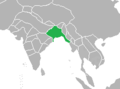
 Map of Rakhine (Arakan) State in Myanmar.png 651 × 1,047; 56 KB
-
 Maungdaw district in Rakhine state.svg 532 × 596; 277 KB
-
 Maungdaw tsp in Maungdaw district.svg 632 × 565; 39 KB
-
 Minbya tsp in MraukU district.svg 640 × 526; 77 KB
-
 MraukU district in Rakhine state.svg 335 × 418; 279 KB
-
 MraukU district.svg 433 × 550; 83 KB
-
 MraukU tsp in MraukU district.svg 657 × 664; 77 KB
-
 Munaung tsp in KyaukPhyu district.svg 777 × 724; 52 KB
-
 Mungaung tsp in Toungup district.svg 400 × 333; 38 KB
-
 Myanmar-Loc-Rakhine-State.png 255 × 498; 48 KB
-
 Myebon tsp in MraukU district.svg 620 × 604; 77 KB
-
 Northern Rakhine State (crop).png 243 × 415; 6 KB
-
 Pauktaw tsp in Sittwe district.svg 422 × 442; 52 KB
-
 Ponnagyun tsp in Sittwe district.svg 545 × 558; 52 KB
-
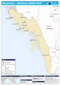
 Rakhine State Base Map.png 2,384 × 2,829; 310 KB
-
 Rakhine state districts map 2022.svg 278 × 401; 296 KB
-
 Rakhine State in Myanmar (cropped).jpg 285 × 230; 66 KB
-
 Rakhine State in Myanmar 2010.svg 1,228 × 2,003; 985 KB
-
 Rakhine State in Myanmar.jpg 285 × 599; 119 KB
-
 Ramree tsp in Kyaukphyu district 2022.svg 489 × 595; 30 KB
-
 Ramree tsp in KyaukPhyu district.svg 659 × 628; 52 KB
-
 Rathedaung tsp in Sittwe district.svg 732 × 747; 52 KB
-
 Sittwe district in Rakhine state.svg 801 × 1,031; 277 KB
-
 Sittwe district.svg 477 × 806; 58 KB
-
 Sittwe tsp in Sittwe district.svg 651 × 672; 52 KB
-
 Thandwe district in Rakhine state 2022.svg 278 × 401; 296 KB
-
 Thandwe district in Rakhine state.svg 212 × 326; 280 KB
-
 Thandwe tsp in Thandwe district 2022.svg 311 × 565; 64 KB
-
 Thandwe tsp in Thandwe district.svg 577 × 620; 85 KB
-
 Toungup district in Rakhine state.svg 278 × 401; 296 KB
-
 Toungup tsp in Thandwe district.svg 657 × 624; 85 KB
-
 Toungup tsp in Toungup district.svg 400 × 333; 38 KB


_State_in_Myanmar.png)


.png)


.jpg)


