Category:Maps of Saint-Amans-des-Cots
Jump to navigation
Jump to search
Wikimedia category | |||||
| Upload media | |||||
| Instance of | |||||
|---|---|---|---|---|---|
| Category combines topics | |||||
| Saint-Amans-des-Cots | |||||
commune in Aveyron, France  .svg)  | |||||
| Instance of |
| ||||
| Part of | |||||
| Location |
| ||||
| Legal form |
| ||||
| Population |
| ||||
| Area |
| ||||
| Replaces |
| ||||
| official website | |||||
 | |||||
Media in category "Maps of Saint-Amans-des-Cots"
The following 10 files are in this category, out of 10 total.
-
 12209-Saint-Amans-des-Cots-Arron.png 3,057 × 2,480; 1.25 MB
-
 12209-Saint-Amans-des-Cots-cadastre.svg 961 × 744; 6.53 MB
-
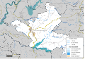
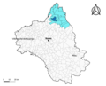 12209-Saint-Amans-des-Cots-Canton.png 3,057 × 2,480; 1.25 MB
-
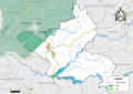
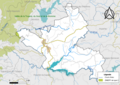
 12209-Saint-Amans-des-Cots-Hydro.png 3,519 × 2,480; 2.64 MB
-
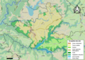
 12209-Saint-Amans-des-Cots-Natura2000.png 7,039 × 4,960; 5.2 MB
-
 12209-Saint-Amans-des-Cots-Sols.png 3,507 × 2,480; 2.98 MB
-
 12209-Saint-Amans-des-Cots-ZNIEFF1.png 3,519 × 2,480; 2.39 MB
-
 12209-Saint-Amans-des-Cots-ZNIEFF2.png 3,519 × 2,480; 2.26 MB
-
 12209-Saint-Amans-des-Cots-Zone inondable.svg 1,070 × 744; 4 MB
-
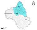
 Map commune FR insee code 12209.png 756 × 605; 60 KB


