English: Maps of Saint Croix National Scenic Riverway
<nowiki>Category:Maps of Saint Croix National Scenic Riverway; विकिमिडिया श्रेणी; หน้าหมวดหมู่วิกิมีเดีย; κατηγορία εγχειρημάτων Wikimedia; Wikimedia-kategorie; Wikimedia-Kategorie; Wikimedia:Ronnaghys; 維基媒體分類; Wikimedia category; kategori Wikimedia; катэгорыя ў праекце Вікімэдыя; Wikimedia-categorie; kategori e Wikimedias; Wikimedia category; Wikimedia:Klassys; категория на Уикимедия; kategoria w projekcie Wikimedia; categorie în cadrul unui proiect Wikimedia; categurìa 'e nu pruggette Wikimedia; Wikimedia category; ویکیمیڈیا زمرہ; kategória projektov Wikimedia; Wîkîmediya:Kategorî; категорія проєкту Вікімедіа; kawan Wikimèdia; гурӯҳи Викимедиа; 维基媒体分类; Wikimedia-Kategorie; 위키미디어 분류; Wikimedia-bólkur; kategorio en Vikimedio; Викимедиина категорија; kategorija na Wikimediji; categoría de Wikimedia; উইকিমিডিয়া বিষয়শ্রেণী; page de catégorie de Wikimedia; kategori Wikimedia; kategorija na Wikimediji; Wikimedia proyektındağı törkem; 维基媒体分类; विकिपीडिया:श्रेणी; kategorie na projektech Wikimedia; विकिपीडिया वर्ग; kategorija w projektach Wikimedije; thể loại Wikimedia; Wikimedia-Kategorie; Wikimedia projekta kategorija; kategoria ti Wikimedia; категорија на Викимедији; Vikimédia ñemohenda; categoría de Wikimedia; categoria de um projeto da Wikimedia; 维基媒体分类; категорияд Ангилал; Wikimedia-kategori; Wikimedia-kategori; kategori Wikimédia; kategori Wikimedia; ვიკიპედია:კატეგორიზაცია; Wikimedia-kategori; پۆلی ویکیمیدیا; Wikimedia category; تصنيف ويكيميديا; pajenn rummata eus Wikimedia; 維基媒體分類; Wikimedia:ကဏ္ဍခွဲခြင်း; 維基媒體分類; Wikimedia категориясы; વિકિપીડિયા શ્રેણી; Wikimedia-categorie; Wikimediako kategoria; tudalen categori Wikimedia; categoría de Wikimedia; категория в проекте Викимедиа; Викимедиа категорияһы; Wikimedia-Kategorie; Wikimedia-kategori; катэгорыя ў праекце Вікімедыя; Վիքիմեդիայի նախագծի կատեգորիա; 维基媒体分类; Wikimedia-kategory; विकिमिडिया श्रेणी; ウィキメディアのカテゴリ; Wikimedia-Kategorie; ردهٔ ویکیپدیا; تصنيف بتاع ويكيميديا; Wikimedia kategooria; විකිමීඩියා ප්රභේද පිටුව; categoria Vicimediorum; Vikimedya kategorisi; Vikipidiya:Shopni; categoria Wikimedia; Wikimedia-kategoriija; гурӯҳ дар лоиҳаи Викимедиа; Wikimedia-categorie; Wikimedia-Kategorie; விக்கிமீடியப் பகுப்பு; categoria di un progetto Wikimedia; gurühi Vikimedia; Wikimedia-Kategorie; Wikimedia-luokka; 維基媒體分類; विकिमीडिया श्रेणी; Викимедиа проектындагы төркем; Викимедиа проектындагы төркем; דף קטגוריה; ẹ̀ka Wikimedia; catigurìa di nu pruggettu Wikimedia; categoria de um projeto da Wikimedia; Wikimedia-kategorie; Kategoriya ning Wikimedia; tumbung Wikimedia; categoria de Wikimedia; kategorija Wikimedije; kategorya ng Wikimedia; kategori Wikimedia; Wikimédia-kategória; kategori Wikimedia; jamii ya Wikimedia; വിക്കിമീഡിയ വർഗ്ഗം; 維基媒體分類; kategori Wikimedia; د ويکيمېډيا وېشنيزه; زمرو:وڪيپيڊيا زمرا بندي; Wikimedia-Kategorie; categoría de Wikimedia; Wikimedia:Kategorija; 维基媒体分类; Viciméid catagóir</nowiki>


.jpg)

 NPS namekagon-river-map-1-namekagon-dam.jpg 2,025 × 1,560; 504 KB
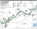 NPS namekagon-river-map-2-hayward-landing.jpg 2,032 × 1,572; 435 KB
 NPS namekagon-river-map-3-trego.jpg 2,014 × 1,557; 533 KB
 NPS saint-croix-river-map-10-boom-site-landing.jpg 1,540 × 2,590; 619 KB
 NPS saint-croix-river-map-4-gordon-dam-landing.jpg 1,532 × 2,068; 521 KB
 NPS saint-croix-river-map-5-riverside-landing.jpg 2,061 × 1,605; 492 KB
 NPS saint-croix-river-map-6-sand-creek-landing.jpg 1,572 × 2,064; 464 KB
 NPS saint-croix-river-map-7-highway-70-landing.jpg 1,520 × 2,052; 579 KB
 NPS saint-croix-river-map-8-osceola-landing.jpg 1,532 × 2,068; 546 KB
 NPS saint-croix-river-map-9-high-bridge.jpg 1,528 × 2,068; 562 KB
 NPS saint-croix-river-map.jpg 3,370 × 3,945; 1.55 MB
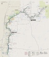 NPS saint-croix-river-map.pdf 2,527 × 2,958; 7.01 MB


