Category:Maps of Saxe-Lauenburg
Jump to navigation
Jump to search
Media in category "Maps of Saxe-Lauenburg"
The following 20 files are in this category, out of 20 total.
-
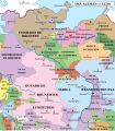
 Grafschaften Holstein Ratzeburg Schwerin Dannenberg Luechow 1250.png 700 × 796; 284 KB
-
 Północno-wschodnie Niemcy ok 1250-es.svg 1,759 × 2,000; 1.48 MB
-
 Północno-wschodnie Niemcy ok 1250.svg 700 × 796; 1.7 MB
-
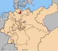
 Herzogtum Sachsen Lauenburg 1400.PNG 349 × 343; 88 KB
-
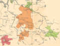
 Map of the Duchy of Saxe-Lauenburg (1580)-EN.svg 992 × 943; 69 KB
-
 Map of the Duchy of Saxe-Lauenburg (1580)-es.svg 992 × 943; 194 KB
-
 The Free and Hanseatic Cities of Lübeck, Hamburg and Bremen.jpg 1,513 × 1,023; 649 KB
-

-
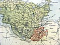
 Reilly 302.jpg 1,132 × 902; 417 KB
-
 Map-DB-Sachsen-Lauenburg.svg 1,793 × 1,571; 1.67 MB
-
 1848년라우엔부르크.png 654 × 542; 19 KB
-
 Lauenburg1848.png 654 × 542; 23 KB
-
 SleeswijkHolsteinLauenburg1848.png 361 × 418; 29 KB
-
 Meyer‘s Zeitungsatlas 106 – Holstein mit Lauenburg, Hamburg und Lübeck.jpg 7,243 × 6,070; 15.86 MB
-
 1866 Black Holstein.jpg 940 × 705; 327 KB
-
 Herzogtümer.png 2,000 × 2,395; 791 KB
-
 Kort 2. Slesvigske Krig Militære begivenheder.png 1,861 × 2,228; 713 KB
-
 Hertugdømmerne.png 2,000 × 2,395; 800 KB
-
 Karte Düppeler Schanzen im Deutsch-Dänischen Krieg.png 1,000 × 1,171; 315 KB
-
 Sächsische-Herzogtümer 1235.png 702 × 544; 782 KB


-EN.svg)
-es.svg)


