Category:Maps of South Sudanese civil war
Jump to navigation
Jump to search
Media in category "Maps of South Sudanese civil war"
The following 7 files are in this category, out of 7 total.
-
 2016–17 Wau clashes locations.png 849 × 780; 152 KB
-
 21 States of South Sudan.png 1,000 × 673; 40 KB
-
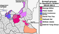 Armed groups in South Sudan in 2011.png 1,542 × 889; 132 KB
-
 South Sudan - Displacement snapshot as of March 2017.png 2,000 × 1,545; 2.41 MB
-
 South Sudan conflict map.png 500 × 363; 69 KB
-
 Southern Sudan Civil War.svg 1,561 × 1,133; 1.71 MB
-
 SouthSudan.jpg 1,273 × 901; 227 KB


