Category:Maps of Western Cape municipalities with 2011 borders
Jump to navigation
Jump to search
This category contains maps of municipalities in the Western Cape province of South Africa that show the the municipal borders as they were after the municipal election of 18 May 2011. The borders of many municipalities across the country changed again in 2016.
Media in category "Maps of Western Cape municipalities with 2011 borders"
The following 44 files are in this category, out of 44 total.
-
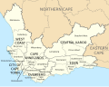
 Map of the Western Cape with districts labelled (2011).svg 849 × 676; 385 KB
-
 Map of the Western Cape with municipalities blank (2011).svg 849 × 676; 747 KB
-
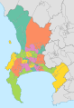
 Map of the Western Cape with municipalities labelled (2011).svg 849 × 676; 541 KB
-
 Map of the Western Cape with Beaufort West highlighted (2011).svg 849 × 676; 337 KB
-
 Map of the Western Cape with Bergrivier highlighted (2011).svg 849 × 676; 335 KB
-
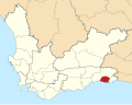
 Map of the Western Cape with Bitou highlighted (2011).svg 849 × 676; 331 KB
-
 Blank map of the Western Cape (2011).svg 805 × 621; 345 KB
-
 Map of the Western Cape with Breede Valley highlighted (2011).svg 849 × 676; 329 KB
-
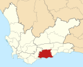
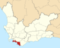
 Map of the Western Cape with Cape Agulhas highlighted (2011).svg 849 × 676; 335 KB
-
 Map of South Africa with Cape Town highlighted (2011).svg 809 × 709; 495 KB
-
 Map of the Western Cape with Cape Town highlighted (2011).svg 849 × 676; 341 KB
-
 Cape Town subcouncils 2011.svg 642 × 934; 447 KB
-
 Cape Town subcouncils and wards 2011.svg 642 × 934; 1.6 MB
-
 Map of South Africa with Cape Winelands highlighted (2011).svg 809 × 709; 497 KB
-
 Map of the Western Cape with Cape Winelands highlighted (2011).svg 849 × 676; 340 KB
-
 Map of the Western Cape with Cederberg highlighted (2011).svg 849 × 676; 335 KB
-
 Map of South Africa with Central Karoo highlighted (2011).svg 809 × 709; 498 KB
-
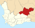
 Map of the Western Cape with Central Karoo highlighted (2011).svg 849 × 676; 339 KB
-
 Map of the Western Cape with Drakenstein highlighted (2011).svg 849 × 676; 332 KB
-
 Map of South Africa with Eden highlighted (2011).svg 809 × 709; 499 KB
-
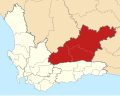
 Map of the Western Cape with Eden highlighted (2011).svg 849 × 676; 349 KB
-
 Map of the Western Cape with George highlighted (2011).svg 849 × 676; 333 KB
-
 Map of the Western Cape with Hessequa highlighted (2011).svg 849 × 676; 338 KB
-
 Kaart van Wes-Kaap munisipaliteite (2011).svg 849 × 676; 540 KB
-
 Map of the Western Cape with Kannaland highlighted (2011).svg 849 × 676; 329 KB
-
 Map of the Western Cape with Knysna highlighted (2011).svg 849 × 676; 329 KB
-
 Map of the Western Cape with Laingsburg highlighted (2011).svg 849 × 676; 333 KB
-
 Map of the Western Cape with Langeberg highlighted (2011).svg 849 × 676; 330 KB
-

-
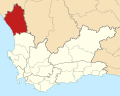 Map of the Western Cape with Matzikama highlighted (2011).svg 849 × 676; 341 KB
-
 Map of the Western Cape with Mossel Bay highlighted (2011).svg 849 × 676; 334 KB
-
 Map of the Western Cape with Oudtshoorn highlighted (2011).svg 849 × 676; 330 KB
-
 Map of South Africa with Overberg highlighted (2011).svg 809 × 709; 499 KB
-
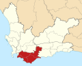 Map of the Western Cape with Overberg highlighted (2011).svg 849 × 676; 348 KB
-
 Map of the Western Cape with Overstrand highlighted (2011).svg 849 × 676; 337 KB
-
 Map of the Western Cape with Prince Albert highlighted (2011).svg 849 × 676; 330 KB
-
 Map of the Western Cape with Saldanha Bay highlighted (2011).svg 849 × 676; 340 KB
-
 Map of the Western Cape with Stellenbosch highlighted (2011).svg 849 × 676; 330 KB
-
 Map of the Western Cape with Swartland highlighted (2011).svg 849 × 676; 337 KB
-
 Map of the Western Cape with Swellendam highlighted (2011).svg 849 × 676; 334 KB
-
 Map of the Western Cape with Theewaterskloof highlighted (2011).svg 849 × 676; 330 KB
-
 Map of South Africa with West Coast highlighted (2011).svg 809 × 709; 506 KB
-
 Map of the Western Cape with West Coast highlighted (2011).svg 849 × 676; 364 KB
-
 Map of the Western Cape with Witzenberg highlighted (2011).svg 849 × 676; 333 KB
.svg)
.svg)
.svg)
.svg)
.svg)
.svg)
.svg)
.svg)
.svg)


.svg)
.svg)
.svg)
.svg)
.svg)
.svg)
.svg)
.svg)
.svg)
.svg)
.svg)
.svg)
.svg)
.svg)
.svg)
.svg)
.svg)
.svg)
.svg)
.svg)
.svg)
.svg)
.svg)
.svg)
.svg)
.svg)
.svg)
.svg)
.svg)
.svg)
.svg)
.svg)
.svg)