Category:Maps of Winchester, Massachusetts
Jump to navigation
Jump to search
Subcategories
This category has only the following subcategory.
Media in category "Maps of Winchester, Massachusetts"
The following 12 files are in this category, out of 12 total.
-
 1851 Medford and Stoneham Branch Railroad map.jpg 9,526 × 3,639; 4.5 MB
-

-

-

-

-

-

-
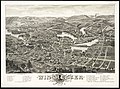
 Map of the town of Winchester, Middlesex County, Mass. (7557376624).jpg 6,285 × 4,248; 25.28 MB
-

-
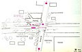 Plan of Cross Street station, 1977.jpg 3,070 × 1,970; 383 KB
-
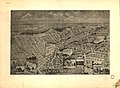 Winchester, Massachusetts 1898. LOC 75694610.jpg 9,440 × 6,928; 8.16 MB
-
 Winchester, Middlesex County, Mass. (2674709248).jpg 2,000 × 1,481; 2.79 MB


.jpg)


.jpg)