Category:Maps of borders of Algeria
Jump to navigation
Jump to search
Media in category "Maps of borders of Algeria"
The following 18 files are in this category, out of 18 total.
-
 Algeria-Libya boundary.jpg 3,155 × 4,201; 9.43 MB
-
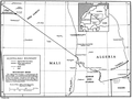 Algeria-Mali border map.png 1,319 × 987; 156 KB
-
 Algeria-Mauritania boundary. LOC 84692345.jpg 4,137 × 3,171; 1.06 MB
-
 Algeria-Mauritania boundary. LOC 84692345.tif 4,137 × 3,171; 37.53 MB
-
 Algeria-Mauritania boundary.jpg 4,137 × 3,171; 9.76 MB
-
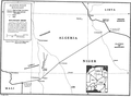 Algeria-Niger border map.png 1,135 × 840; 188 KB
-
 Algeria-Spanish Sahara boundary.jpg 3,157 × 4,179; 9.14 MB
-
 Fort Charlet (Djanet).jpg 7,977 × 8,082; 7.03 MB
-
 Fort Tarat.jpg 9,147 × 7,299; 8.18 MB
-
 French Algeria evolution 1830-1962 map-es.svg 1,373 × 1,363; 1.71 MB
-
 French Algeria evolution 1830-1962 map-fr.svg 1,287 × 1,278; 1.86 MB
-
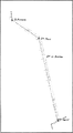 Frontiere algerie tunisie bir romane fort saint.PNG 358 × 652; 13 KB
-
 Frontière Maroc-Algérie 1963-ar.svg 632 × 370; 357 KB
-
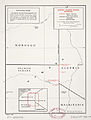
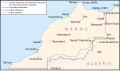
 Frontière Maroc-Algérie 1963.png 2,107 × 1,232; 242 KB
-
 Frontière Maroc-Algérie 1963.svg 632 × 370; 134 KB
-
 Maritime borders between Algeria and Morocco.png 1,288 × 1,184; 822 KB
-
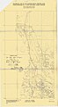 Provisional Map of the Algerian-Libyan Frontier Zone 26.30-27.30.jpg 1,449 × 2,631; 584 KB
-
 Provisional Map of the Algerian-Libyan Frontier Zone 27.30-29.00.jpg 1,495 × 3,698; 879 KB


.jpg)


