Category:Maps of districts of Gauteng
Jump to navigation
Jump to search
Media in category "Maps of districts of Gauteng"
The following 11 files are in this category, out of 11 total.
-
 Map of Gauteng with Ekurhuleni highlighted (2016).svg 754 × 760; 223 KB
-
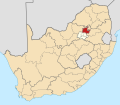
 Map of South Africa with Ekurhuleni highlighted (2016).svg 809 × 709; 672 KB
-
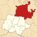
 Map of Gauteng with Johannesburg highlighted (2016).svg 754 × 760; 227 KB
-
 Map of South Africa with Johannesburg highlighted (2016).svg 809 × 709; 672 KB
-
 Map of Gauteng with Sedibeng highlighted (2011).svg 754 × 760; 162 KB
-
 Map of Gauteng with Sedibeng highlighted (2016).svg 754 × 760; 243 KB
-
 Map of South Africa with Sedibeng highlighted (2016).svg 809 × 709; 677 KB
-
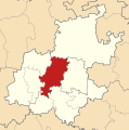
 Map of Gauteng with Tshwane highlighted (2016).svg 754 × 760; 228 KB
-
 Map of South Africa with Tshwane highlighted (2016).svg 809 × 709; 675 KB
-
 Map of Gauteng with West Rand highlighted (2016).svg 754 × 760; 226 KB
-
 Map of South Africa with West Rand highlighted (2016).svg 809 × 709; 673 KB
.svg)
.svg)
.svg)
.svg)
.svg)
.svg)
.svg)
.svg)
.svg)
.svg)
.svg)