Category:Maps of districts of the Eastern Cape
Jump to navigation
Jump to search
Media in category "Maps of districts of the Eastern Cape"
The following 16 files are in this category, out of 16 total.
-
 Map of South Africa with Alfred Nzo highlighted (2016).svg 809 × 709; 719 KB
-
 Map of the Eastern Cape with Alfred Nzo highlighted (2016).svg 928 × 620; 671 KB
-
 Map of South Africa with Amathole highlighted (2016).svg 809 × 709; 728 KB
-
 Map of the Eastern Cape with Amathole highlighted (2016).svg 928 × 620; 689 KB
-
 Map of South Africa with Buffalo City highlighted (2016).svg 809 × 709; 707 KB
-
 Map of the Eastern Cape with Buffalo City highlighted (2016).svg 928 × 620; 640 KB
-
 Map of South Africa with Chris Hani highlighted (2016).svg 809 × 709; 720 KB
-
 Map of the Eastern Cape with Chris Hani highlighted (2016).svg 928 × 620; 657 KB
-
 Map of South Africa with Joe Gqabi highlighted (2016).svg 809 × 709; 723 KB
-
 Map of the Eastern Cape with Joe Gqabi highlighted (2016).svg 928 × 620; 672 KB
-
 Map of South Africa with Nelson Mandela Bay highlighted (2016).svg 809 × 709; 704 KB
-
 Map of the Eastern Cape with Nelson Mandela Bay highlighted (2016).svg 928 × 620; 631 KB
-
 Map of South Africa with OR Tambo highlighted (2016).svg 809 × 709; 719 KB
-
 Map of the Eastern Cape with OR Tambo highlighted (2016).svg 928 × 620; 672 KB
-
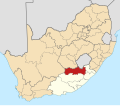
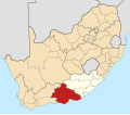 Map of South Africa with Sarah Baartman highlighted (2016).svg 809 × 709; 724 KB
-
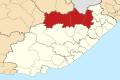
 Map of the Eastern Cape with Sarah Baartman highlighted (2016).svg 928 × 620; 669 KB
.svg)
.svg)
.svg)
.svg)
.svg)
.svg)
.svg)
.svg)
.svg)
.svg)
.svg)
.svg)
.svg)
.svg)
.svg)
.svg)