Category:Maps of geologic groups of Canada
Jump to navigation
Jump to search
Media in category "Maps of geologic groups of Canada"
The following 13 files are in this category, out of 13 total.
-
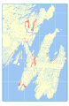 Adeyton Group map.svg 512 × 786; 26.64 MB
-
 Bell Island Group map.svg 512 × 786; 26.46 MB
-
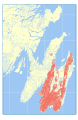 Conception Group map.svg 512 × 786; 28.29 MB
-
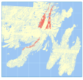
 Connecting Point Group map.svg 512 × 838; 27.45 MB
-
 Harbour Main Group map.svg 512 × 786; 27.14 MB
-
 Harcourt Group map.svg 512 × 786; 26.71 MB
-
 Love Cove Group map.svg 512 × 488; 27.4 MB
-
 Marystown Group map.svg 512 × 458; 27.97 MB
-
 Musgravetown Group map.svg 512 × 837; 30.63 MB
-
 Signal Hill Group map.svg 512 × 786; 27.01 MB
-
 St. John's Group map.svg 512 × 786; 26.97 MB
-
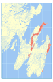
 Wabana Group map.svg 512 × 786; 26.44 MB
-
 Young's Cove Group map.svg 512 × 458; 26.42 MB


