Category:Maps of industrial areas in Italy
Jump to navigation
Jump to search
Media in category "Maps of industrial areas in Italy"
The following 22 files are in this category, out of 22 total.
-

-

-
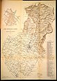 Carta topografica laniera del Comune di Prato (1918).jpg 4,543 × 6,532; 17.66 MB
-

-

-

-

-

-

-
-

-
 Map Dimensional aspects of industry 1992 - Touring Club Italiano CART-TEM-077.jpg 5,000 × 3,468; 9.56 MB
-
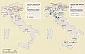
 Map Early industrialization 1992 - Touring Club Italiano CART-TEM-073.jpg 5,000 × 3,467; 9.7 MB
-
 Map Industrial employment 1989 - Touring Club Italiano CART-TEM-074.jpg 5,000 × 3,450; 10.21 MB
-
 Map Industrial productions I 1990 - Touring Club Italiano CART-TEM-075.jpg 5,000 × 3,476; 9.66 MB
-
 Map Industrial productions II 1990 - Touring Club Italiano CART-TEM-076.jpg 5,000 × 3,402; 9.05 MB
-
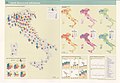
 Map Industry in the Mezzogiorno 1989 - Touring Club Italiano CART-TEM-079.jpg 5,000 × 3,447; 10.62 MB
-
 Map Italian industry in the world 1990 - Touring Club Italiano CART-TEM-078.jpg 5,000 × 3,387; 10.8 MB
-
 Map Service industries 1992 - Touring Club Italiano CART-TEM-081.jpg 5,000 × 3,416; 10.59 MB
-
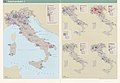
 Map Types of industries 1992 - Touring Club Italiano CART-TEM-080.jpg 5,000 × 3,488; 10.8 MB
-
-


.jpg)


