Category:Maps of local government areas in Brisbane
Jump to navigation
Jump to search
Media in category "Maps of local government areas in Brisbane"
The following 19 files are in this category, out of 19 total.
-
 BrisbaneCity-QldLGA.svg 1,200 × 1,000; 3.94 MB
-
 IpswichCity-QldLGA.svg 1,200 × 1,000; 1.82 MB
-
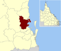
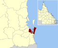
 LoganCity-QldLGA.svg 1,200 × 1,000; 1.85 MB
-
 Moreton bay LGA Qld 2008.png 124 × 159; 10 KB
-
 MoretonBayRegion-QldLGA.svg 1,200 × 1,000; 2.02 MB
-
 Old lga Caboolture.png 135 × 175; 14 KB
-
 RedlandCity-QldLGA.svg 1,200 × 1,000; 2.09 MB
-
 SEQ-Councils-Brisbane.png 820 × 1,280; 310 KB
-
 SEQ-Councils-Ipswich.png 820 × 1,280; 310 KB
-
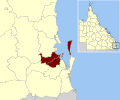
 SEQ-Councils-Logan.png 820 × 1,280; 311 KB
-
 SEQ-Councils-MoretonBay.png 820 × 1,280; 309 KB
-
 SEQ-Councils-Redland.png 820 × 1,280; 315 KB
-
 SEQ-U-LGA-map-BCC.png 1,390 × 2,836; 381 KB
-
 SEQ-U-LGA-map-CSC.png 1,390 × 2,836; 380 KB
-
 SEQ-U-LGA-map-ICC.png 1,390 × 2,836; 382 KB
-
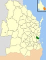
 SEQ-U-LGA-map-LCC.png 1,390 × 2,836; 381 KB
-
 SEQ-U-LGA-map-PRSC.png 1,390 × 2,836; 381 KB
-
 SEQ-U-LGA-map-RCC.png 1,390 × 2,836; 381 KB
-
 SEQ-U-LGA-map-RSC.png 1,390 × 2,836; 382 KB


