Category:Maps of local government areas in Newcastle
Jump to navigation
Jump to search
Media in category "Maps of local government areas in Newcastle"
The following 12 files are in this category, out of 12 total.
-
 Australia-Map-NSW-LGA-LakeMacquarie.png 720 × 593; 32 KB
-
 Australia-Map-NSW-LGA-Maitland.png 720 × 593; 30 KB
-
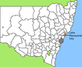
 Australia-Map-NSW-LGA-Newcastle.png 720 × 593; 31 KB
-
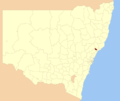
 Australia-Map-NSW-LGA-PortStephens.png 720 × 593; 31 KB
-
 Lake Macquarie LGA location map.svg 800 × 573; 19 KB
-
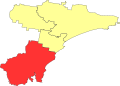
 Lake macquarie LGA NSW.png 400 × 337; 33 KB
-
 Maitland LGA location map.svg 800 × 573; 19 KB
-
 Maitland LGA NSW.png 400 × 337; 33 KB
-
 Newcastle LGA location map.svg 800 × 573; 19 KB
-
 Newcastle LGA NSW.png 400 × 337; 33 KB
-
 Port Stephens LGA location map.svg 800 × 573; 19 KB
-
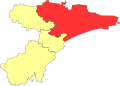
 Port stephens LGA NSW.png 400 × 337; 33 KB


