Category:Maps of municipalities in Entremont District to 2020
Jump to navigation
Jump to search
Media in category "Maps of municipalities in Entremont District to 2020"
The following 7 files are in this category, out of 7 total.
-
 Karte Gemeinden des Bezirks Entremont 2007.png 1,476 × 1,346; 365 KB
-
 Karte Gemeinde Bagnes 2007.png 1,476 × 1,346; 367 KB
-
 Karte Gemeinde Bourg-Saint-Pierre 2007.png 1,476 × 1,346; 366 KB
-
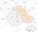
 Karte Gemeinde Liddes 2007.png 1,476 × 1,346; 366 KB
-
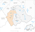 Karte Gemeinde Orsières 2007.png 1,476 × 1,346; 367 KB
-
 Karte Gemeinde Sembrancher 2007.png 1,476 × 1,346; 366 KB
-
 Karte Gemeinde Vollèges 2007.png 1,476 × 1,346; 366 KB


