Category:Maps of municipalities in the district of Emmental to 2020
Jump to navigation
Jump to search
Media in category "Maps of municipalities in the district of Emmental to 2020"
The following 41 files are in this category, out of 41 total.
-
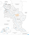
 Karte Gemeinden des Verwaltungskreis Emmental 2016.png 1,476 × 1,740; 774 KB
-
 Karte Gemeinde Aefligen 2016.png 1,476 × 1,740; 774 KB
-
 Karte Gemeinde Affoltern im Emmental 2016.png 1,476 × 1,740; 775 KB
-
 Karte Gemeinde Alchenstorf 2016.png 1,476 × 1,740; 774 KB
-
 Karte Gemeinde Burgdorf 2016.png 1,476 × 1,740; 776 KB
-
 Karte Gemeinde Bätterkinden 2016.png 1,476 × 1,740; 774 KB
-
 Karte Gemeinde Dürrenroth 2016.png 1,476 × 1,740; 775 KB
-
 Karte Gemeinde Eggiwil 2016.png 1,476 × 1,740; 776 KB
-
 Karte Gemeinde Ersigen 2016.png 1,476 × 1,740; 775 KB
-
 Karte Gemeinde Hasle bei Burgdorf 2016.png 1,476 × 1,740; 775 KB
-
 Karte Gemeinde Heimiswil 2016.png 1,476 × 1,740; 776 KB
-
 Karte Gemeinde Hellsau 2016.png 1,476 × 1,740; 774 KB
-
 Karte Gemeinde Hindelbank 2016.png 1,476 × 1,740; 775 KB
-
 Karte Gemeinde Höchstetten 2016.png 1,476 × 1,740; 774 KB
-
 Karte Gemeinde Kernenried 2016.png 1,476 × 1,740; 774 KB
-
 Karte Gemeinde Kirchberg 2016.png 1,476 × 1,740; 775 KB
-
 Karte Gemeinde Koppigen 2016.png 1,476 × 1,740; 774 KB
-
 Karte Gemeinde Krauchthal 2016.png 1,476 × 1,740; 775 KB
-
 Karte Gemeinde Langnau im Emmental 2016.png 1,476 × 1,740; 776 KB
-
 Karte Gemeinde Lauperswil 2016.png 1,476 × 1,740; 775 KB
-
 Karte Gemeinde Lyssach 2016.png 1,476 × 1,740; 774 KB
-
 Karte Gemeinde Lützelflüh 2016.png 1,476 × 1,740; 776 KB
-
 Karte Gemeinde Mötschwil 2016.png 1,476 × 1,740; 774 KB
-
 Karte Gemeinde Oberburg 2016.png 1,476 × 1,740; 775 KB
-
 Karte Gemeinde Rumendingen 2016.png 1,476 × 1,740; 774 KB
-
 Karte Gemeinde Röthenbach im Emmental 2016.png 1,476 × 1,740; 775 KB
-
 Karte Gemeinde Rüderswil 2016.png 1,476 × 1,740; 775 KB
-
 Karte Gemeinde Rüdtligen-Alchenflüh 2016.png 1,476 × 1,740; 774 KB
-
 Karte Gemeinde Rüegsau 2016.png 1,476 × 1,740; 775 KB
-
 Karte Gemeinde Rüti bei Lyssach 2016.png 1,476 × 1,740; 774 KB
-
 Karte Gemeinde Schangnau 2016.png 1,476 × 1,740; 775 KB
-
 Karte Gemeinde Signau 2016.png 1,476 × 1,740; 775 KB
-
 Karte Gemeinde Sumiswald 2016.png 1,476 × 1,740; 776 KB
-
 Karte Gemeinde Trachselwald 2016.png 1,476 × 1,740; 775 KB
-
 Karte Gemeinde Trub 2016.png 1,476 × 1,740; 776 KB
-
 Karte Gemeinde Trubschachen 2016.png 1,476 × 1,740; 775 KB
-
 Karte Gemeinde Utzenstorf 2016.png 1,476 × 1,740; 775 KB
-
 Karte Gemeinde Wiler bei Utzenstorf 2016.png 1,476 × 1,740; 774 KB
-
 Karte Gemeinde Willadingen 2016.png 1,476 × 1,740; 774 KB
-
 Karte Gemeinde Wynigen 2016.png 1,476 × 1,740; 775 KB
-
 Karte Gemeinde Zielebach 2016.png 1,476 × 1,740; 774 KB


