Category:Maps of municipalities in the district of Neuchâtel to 2017
Jump to navigation
Jump to search
Media in category "Maps of municipalities in the district of Neuchâtel to 2017"
The following 10 files are in this category, out of 10 total.
-
 Karte Gemeinden des Bezirks Neuchâtel 2009.png 1,476 × 1,369; 426 KB
-
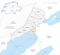
 Karte Gemeinde Cornaux 2009.png 1,476 × 1,369; 427 KB
-
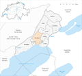
 Karte Gemeinde Cressier NE 2009.png 1,476 × 1,369; 427 KB
-
 Karte Gemeinde Enges 2009.png 1,476 × 1,369; 427 KB
-
 Karte Gemeinde Hauterive NE 2009.png 1,476 × 1,369; 427 KB
-
 Karte Gemeinde La Tène 2009.png 1,476 × 1,369; 427 KB
-
 Karte Gemeinde Le Landeron 2009.png 1,476 × 1,369; 427 KB
-
 Karte Gemeinde Lignières 2009.png 1,476 × 1,369; 427 KB
-
 Karte Gemeinde Neuchâtel 2009.png 1,476 × 1,369; 427 KB
-
 Karte Gemeinde Saint-Blaise 2009.png 1,476 × 1,369; 427 KB


