Category:Maps of municipalities of the canton of Graubünden to 2008
Jump to navigation
Jump to search
Media in category "Maps of municipalities of the canton of Graubünden to 2008"
The following 22 files are in this category, out of 22 total.
-
 Karte Bezirk Albula 2007 blank.png 1,771 × 1,245; 427 KB
-
 Karte Bezirk Albula 2007.png 1,771 × 1,245; 523 KB
-
 Karte Bezirk Bernina 2007 blank.png 1,476 × 1,104; 210 KB
-
 Karte Bezirk Bernina 2007.png 1,476 × 1,104; 258 KB
-
 Karte Bezirk Hinterrhein 2008 blank.png 2,066 × 1,427; 558 KB
-
 Karte Bezirk Hinterrhein 2008.png 2,066 × 1,427; 684 KB
-
 Karte Bezirk Imboden 2007 blank.png 1,771 × 1,049; 275 KB
-
 Karte Bezirk Imboden 2007.png 1,771 × 1,049; 343 KB
-
 Karte Bezirk Inn 2007 blank.png 1,771 × 1,209; 390 KB
-
 Karte Bezirk Inn 2007.png 1,771 × 1,209; 473 KB
-
 Karte Bezirk Landquart 2008 blank.png 1,771 × 1,357; 351 KB
-
 Karte Bezirk Landquart 2008.png 1,771 × 1,357; 442 KB
-
 Karte Bezirk Maloja 2007 blank.png 1,771 × 1,153; 404 KB
-
 Karte Bezirk Maloja 2007.png 1,771 × 1,153; 512 KB
-
 Karte Bezirk Moësa 2007 blank.png 1,624 × 1,269; 349 KB
-
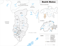 Karte Bezirk Moësa 2007.png 1,624 × 1,269; 434 KB
-
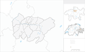 Karte Bezirk Plessur 2008 blank.png 1,771 × 1,087; 335 KB
-
 Karte Bezirk Plessur 2008.png 1,771 × 1,087; 411 KB
-
 Karte Bezirk Prättigau-Davos 2007 blank.png 1,771 × 1,220; 367 KB
-
 Karte Bezirk Prättigau-Davos 2007.png 1,771 × 1,220; 470 KB
-
 Karte Bezirk Surselva 2007 blank.png 1,771 × 1,121; 454 KB
-
 Karte Bezirk Surselva 2007.png 1,771 × 1,121; 562 KB


