Category:Maps of the Algerian railway network during French rule in 1900
Jump to navigation
Jump to search
Media in category "Maps of the Algerian railway network during French rule in 1900"
The following 4 files are in this category, out of 4 total.
-
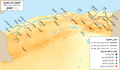 Map of the Algerian railway network (1900) - ar.png 4,800 × 2,798; 8.2 MB
-
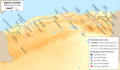
 Map of the Algerian Railway Network (1900) - blank.png 4,800 × 4,150; 1.73 MB
-
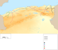
 Map of the Algerian railway network (1900) - fr.png 4,800 × 2,800; 2.16 MB
-
 Réseau ferré algérien en 1900.png 4,800 × 2,800; 826 KB
_-_ar.png)
_-_fr.png)

_-_blank.png)