Category:Maps of the County of Mansfeld
Jump to navigation
Jump to search
Media in category "Maps of the County of Mansfeld"
The following 12 files are in this category, out of 12 total.
-

-

-
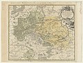
 HStAD P23 Nr111, Karte der Grafschaft Mansfeld, 1751.jpg 1,443 × 1,256; 913 KB
-
-
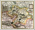
 Blaeu 1645 - Mansfeldia Comitatus.jpg 3,625 × 3,041; 4.4 MB
-

-
 Comitatus Mansfeldia - Henricus Hondius excudit - btv1b530411022 (1 of 2).jpg 6,131 × 4,662; 5.08 MB
-
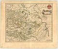
 Mansfeld.jpg 740 × 634; 232 KB
-
 Mansfeldia (Merian).jpg 1,623 × 1,330; 678 KB
-
 Reilly 374.jpg 1,564 × 1,312; 497 KB
-

-
 Atlas ou Representation du Monde Universel t. 2. 1633 (110101141).jpg 17,034 × 12,068; 35.5 MB

.jpg)


.jpg)

.jpg)

.jpg)