Category:Maps of the Mamluk Sultanate (Cairo)
Jump to navigation
Jump to search
English: Maps of Egyptian Mamluk Sultanate (1250—1517).
- The capitol was in Cairo, with territories across Northeastern Africa and the Levant.
Subcategories
This category has the following 2 subcategories, out of 2 total.
B
- Maps of Bahri dynasty (30 F)
- Maps of Burji dynasty (5 F)
Media in category "Maps of the Mamluk Sultanate (Cairo)"
The following 21 files are in this category, out of 21 total.
-
 Mamluk Sultanate.JPG 1,357 × 628; 40 KB
-
 C. 1330 Western Asia under Mongols.jpg 3,993 × 3,000; 3.93 MB
-
 C. 1355 Southeastern Europe.jpg 1,690 × 1,335; 1.37 MB
-
 C. 1360 Europe and Western Asia.jpg 2,112 × 1,365; 2.11 MB
-
 C. 1360 Europe.jpg 4,045 × 3,000; 3.9 MB
-
 Ajjúbidák és Mamlúkok.jpg 2,012 × 1,608; 369 KB
-
 Battle of urfa(1480).png 862 × 597; 88 KB
-
 ByzantinischesReich1265-zh.svg 2,135 × 1,020; 706 KB
-
 ByzantinischesReich1265.svg 1,708 × 816; 555 KB
-
 C. 1481 Southeastern Europe Ottoman Empire.jpg 1,408 × 1,344; 1.01 MB
-
 Carte du Moyen-Orient en 1328-es.svg 1,349 × 909; 414 KB
-
 Mamluk Sultanate Flag of Map (Year-1413).png 1,122 × 1,080; 48 KB
-
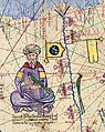 Mamluk Sultanate in the Catalan Atlas (1375), ruler and flags.jpg 619 × 777; 986 KB
-
 Mamluk Sultanate in the Catalan Atlas (1375).jpg 1,129 × 888; 1.36 MB
-
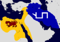
 Mamluk Sultanate or Caliphate map simple.png 1,415 × 972; 240 KB
-
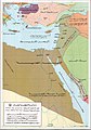
 Map of the Mamluk Sultanate.png 4,928 × 2,500; 26.56 MB
-
 Ottoman–Mamluk War of 1516–17 (Arabic).jpg 800 × 605; 104 KB
-

-
 خطوط الحمام الزاجل في عصر المماليك.png 3,697 × 4,699; 4.68 MB
-
 دولة مصر والشام في عصر المماليك.jpg 679 × 969; 204 KB
-
 ميلاد الدولة العثمانية وتوسعها حتى نهاية عهد سليم الأول.jpg 1,304 × 972; 404 KB


.png)


.png)
,_ruler_and_flags.jpg)
.jpg)


.jpg)


