Category:Maps of the River Medway
Jump to navigation
Jump to search
Media in category "Maps of the River Medway"
The following 16 files are in this category, out of 16 total.
-

-
 A Plan of the River Medway. with the Fortifications adjacent &c. (1725).jpg 4,000 × 2,038; 915 KB
-
 A Plan of the River Medway. with the Fortifications theron 1725.jpg 4,000 × 2,061; 970 KB
-

-

-

-

-
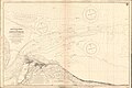 Admiralty Chart No 3683 Approaches to Sheerness, Published 1908, New Edition 1921.jpg 16,271 × 10,880; 52.27 MB
-
 Admiralty Chart No 3683 Sheerness and Approaches, Published 1930.jpg 18,777 × 11,312; 69.59 MB
-
 Chart No 1834 River Medway Stangate Creek to Rochester, Published 1941.jpg 20,443 × 11,286; 111.6 MB
-
 Map of Chatham, Rochester and neighbourhood (1891).jpg 5,823 × 4,886; 4.88 MB
-
 Map of the Medway Megaliths.jpg 694 × 494; 146 KB
-
 Ordnance Survey One-Inch Sheet 172 Chatham & Maidstone, Published 1957.jpg 11,484 × 14,201; 19.32 MB
-
 Ordnance Survey One-inch Sheet 172 Chatham & Maidstone, Published 1970.jpg 11,122 × 13,163; 61.75 MB
-

-
 Print, map (BM 1854,0614.254).jpg 2,500 × 1,916; 1.01 MB
%27_(11253229584).jpg)
.jpg)


.jpg)


_(14596322927).jpg)
.jpg)