Category:Maps of the Small Isles, Lochaber
Jump to navigation
Jump to search
Subcategories
This category has the following 2 subcategories, out of 2 total.
R
- Maps of Rùm (10 F)
Media in category "Maps of the Small Isles, Lochaber"
The following 8 files are in this category, out of 8 total.
-
 Admiralty Chart No 1796 Barra Head to Skye, Published 1959.jpg 9,841 × 6,818; 18.58 MB
-

-

-
 Blaeu - Atlas of Scotland 1654 - INSVLÆ QVÆDAM MINORES - The Small Isles.jpg 6,367 × 4,700; 4.39 MB
-
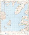
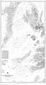 Chart 3674 Southern Approaches to the Minch Scotland.jpg 3,987 × 7,238; 4.72 MB
-
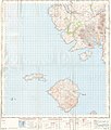 Ordnance Survey One-Inch Sheet 33 Rhum and part of Skye, Published 1957.jpg 8,263 × 9,746; 6.63 MB
-
 Ordnance Survey One-Inch Sheet 34 South Skye and Arisaig, Published 1957.jpg 8,210 × 9,880; 7.19 MB
-
 Ordnance Survey Quarter-inch sheet 4 Western Highlands, published 1967.jpg 9,627 × 8,869; 8.85 MB

.jpg)


