Category:Maps of the Worcester Consolidated Street Railway
Jump to navigation
Jump to search
Media in category "Maps of the Worcester Consolidated Street Railway"
The following 10 files are in this category, out of 10 total.
-
 1902 Worcester Consolidated Street Railway map.jpg 1,806 × 1,779; 395 KB
-
 1906 map of the Worcester Consolidated Street Railway.jpg 1,522 × 1,782; 150 KB
-
 1908 map of street railways around Worcester.jpg 493 × 906; 134 KB
-
 1908 map of street railways between Worcester and New York City.jpg 365 × 1,540; 190 KB
-
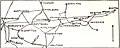 1908 map of streetcar lines between Boston and Worcester.jpg 901 × 364; 101 KB
-
 Consolidated System 1908 map.jpg 3,117 × 2,547; 271 KB
-
 Cover of Boston and Worcester Street Railway brochure.jpg 4,639 × 4,944; 6.95 MB
-
 New Haven electric railway subsidiaries.svg 1,400 × 800; 2.29 MB
-
 Worcester Consolidated Street Railway 1908 map.jpg 1,118 × 1,106; 119 KB
-
 Worcester Consolidated Street Railway Company c 1894.png 2,132 × 1,526; 2.92 MB


