Category:Maps of the exploration of Antarctica
Jump to navigation
Jump to search
Subcategories
This category has only the following subcategory.
M
- Maps of the Endurance Expedition (22 F)
Media in category "Maps of the exploration of Antarctica"
The following 63 files are in this category, out of 63 total.
-
 Admiralty Sound.png 1,212 × 773; 1,003 KB
-
 Antarctica, Bouvet Island, discovery map 1739.jpg 3,836 × 2,916; 2.92 MB
-
 Antarctica, Bouvet Island, discovery map 1754.jpg 3,896 × 3,088; 4.16 MB
-
 Aurora's drift map-fr.svg 1,560 × 1,264; 415 KB
-
 Aurora's drift.png 502 × 363; 13 KB
-
 Bellingshausen-es.svg 503 × 621; 4.35 MB
-
 Bellingshausen-fr.svg 503 × 621; 4.35 MB
-
 Bellingshausen-he.svg 1,025 × 1,264; 1.22 MB
-
 Charles Wilkes-fr.svg 353 × 431; 4.5 MB
-
 Commonwealth Transantarctique Expedition.png 488 × 600; 139 KB
-
 Conquest of Antarctica.jpg 1,064 × 1,457; 650 KB
-
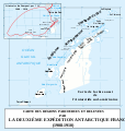
 Deuxième expédition antarctique francaise (1908-1910) (1914) (20897933871).jpg 3,280 × 1,740; 643 KB
-
 Dumont d'Urville-fr.svg 361 × 413; 4.49 MB
-
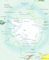
 Expeditions in Antarctica before 1897-ru.svg 503 × 621; 11.61 MB
-
 Expeditions in Antarctica before 1897.png 1,377 × 1,700; 1.03 MB
-
 Expeditions in Antarctica before 1897.svg 503 × 621; 4.52 MB
-
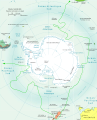
 Expeditions in Antarctica-ar.png 1,256 × 1,553; 706 KB
-
 Expeditions in Antarctica-ar.svg 503 × 621; 3.56 MB
-
 Expeditions in Antarctica-fr.svg 503 × 621; 3.51 MB
-
 Expeditions-in-Antarctica-Roche.png 1,377 × 1,700; 926 KB
-
 First Russian Antarctic Expedition route - fr.svg 1,451 × 2,098; 1.65 MB
-
 First Russian Antarctic Expedition route - ru.svg 1,451 × 2,098; 1.67 MB
-

-
 Henry Worsley's journey 2016 - fr.svg 1,256 × 1,079; 2.75 MB
-
 Henry Worsley's journey 2016 - ru.png 1,256 × 1,079; 1.64 MB
-
 Itinéraire du Pourquoi-Pas.png 1,570 × 1,242; 1.44 MB
-
 Itinéraire du Pourquoi-pas.svg 477 × 503; 444 KB
-
 James Cook-cs.svg 503 × 621; 4.35 MB
-
 James Cook-fr.svg 503 × 621; 4.35 MB
-
 James Ross ESP.svg 503 × 621; 4.33 MB
-
 James Ross-fr.svg 503 × 621; 4.35 MB
-
 Karte antarktis2 exp.png 1,300 × 996; 299 KB
-
 Le pourquoi-pas dans l'Antarctique (Page 5) BHL46836243.jpg 2,232 × 3,260; 575 KB
-
 Le pourquoi-pas dans l'Antarctique BHL46836558.jpg 4,406 × 3,224; 757 KB
-
 Le pourquoi-pas dans l'Antarctique BHL46836570.jpg 4,417 × 5,043; 1.56 MB
-
 Morrell Antarctic Voyage 1822 ru.jpg 502 × 483; 192 KB
-
 Morrell Antarctic Voyage 1822 ZH.jpg 502 × 483; 100 KB
-
 Morrell Antarctic Voyage 1822.png 502 × 483; 15 KB
-
 New South Greenland Map eo.png 400 × 346; 14 KB
-
 New South Greenland Map ua.jpg 398 × 344; 109 KB
-
 New South Greenland Map-blank.png 400 × 346; 8 KB
-
 New South Greenland Map-es.png 400 × 346; 17 KB
-
 New South Greenland Map-fr.png 400 × 346; 11 KB
-
 New South Greenland Map.png 398 × 344; 4 KB
-
 New South Greenland MapZh.png 398 × 344; 26 KB
-
 Nueva Groenlandia del Sur.jpg 400 × 346; 29 KB
-
 PSM V65 D092 Route of the scottish antarctic expedition.png 1,695 × 1,844; 163 KB
-
 PSM V80 D418 Route to the antarctic followed by various explorers.png 1,694 × 1,636; 284 KB
-
 PSM V80 D419 Route to the antarctic followed by ernest shackleton.png 1,678 × 1,630; 272 KB
-
 Roche-Route.PNG 623 × 559; 524 KB
-
 Ross Sea party map-fr.svg 945 × 1,340; 214 KB
-
 RossSeaPartyCarte.png 407 × 623; 17 KB
-
 RossSeaPartyCarteit.png 407 × 623; 19 KB
-
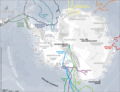
 Route of the Far Eastern party - ru.svg 4,415 × 2,604; 79 KB
-
 Route of the Far Eastern party map-fr.svg 1,803 × 901; 454 KB
-
 Route of the Far Eastern party.png 3,619 × 2,135; 304 KB
-

-
 Shackleton South Georgia Crossing map-es.svg 775 × 500; 742 KB
-
 Shackleton South Georgia Crossing map-fr.svg 775 × 500; 758 KB
-
 ShackletonEndurancecarta it.jpg 502 × 617; 153 KB
-
 The first Antarctic voyage (1839) of the Wilkes expedition-fr.svg 4,552 × 3,458; 636 KB
-
 The first Antarctic voyage (1839) of the Wilkes expedition-ru.png 1,150 × 883; 382 KB
-
 The first Antarctic voyage (1839) of the Wilkes expedition-ru.svg 4,552 × 3,458; 1.04 MB


_(1914)_(20897933871).jpg)


_BHL46836243.jpg)


_of_the_Wilkes_expedition-fr.svg)
_of_the_Wilkes_expedition-ru.png)
_of_the_Wilkes_expedition-ru.svg)