Category:Maps showing 1850
Jump to navigation
Jump to search
| ← 1850 1851 1852 1853 1854 1856 1857 1859→ |
English: Maps showing the year 1850 (i.e. history maps)
See also category: 1850 maps. and 1850s maps for old maps created in this time.
See also category: 1850 maps. and 1850s maps for old maps created in this time.
Subcategories
This category has only the following subcategory.
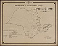
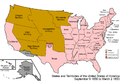
Media in category "Maps showing 1850"
The following 6 files are in this category, out of 6 total.
-
-

-
 United States 1849-1850.png 1,000 × 677; 95 KB
-
 United States 1850-1853-03.png 1,000 × 677; 98 KB
-
 USA Territorial Growth 1850 Alt.jpg 1,136 × 552; 117 KB
-
 Zoutpansberg in 1850s.png 1,286 × 720; 165 KB
.jpg)
.jpg)


