Category:Marcellus Shale maps
Jump to navigation
Jump to search
Media in category "Marcellus Shale maps"
The following 16 files are in this category, out of 16 total.
-
 Annual report of the Regents - New York State Museum. (1895) (19180365389).jpg 2,310 × 2,996; 1.31 MB
-
 Annual report of the Regents - New York State Museum. (1896) (19179983869).jpg 4,036 × 2,170; 2.32 MB
-
 Annual report of the Regents - New York State Museum. (1902) (19178338480).jpg 2,520 × 3,230; 1.69 MB
-
 Annual report on the New York State Museum of Natural History (1881) (19372137191).jpg 2,172 × 3,680; 1.62 MB
-
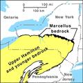 Marcellus Bedrock.pdf 900 × 900; 74 KB
-
 Marcellus Bedrock.svg 540 × 540; 1.21 MB
-
 Marcellus shale isobath map 2019 DE.png 3,507 × 2,480; 4.84 MB
-
 Marcellus shale isopach map 2019 DE.png 3,507 × 2,480; 5.53 MB
-
 Marcellus shale revised map 2019.png 2,820 × 2,480; 534 KB
-
 Marcellus Shale USGS.png 300 × 350; 78 KB
-
 Marcellus Thermal Maturity.png 1,766 × 2,988; 442 KB
-
 NPS delaware-water-gap-geologic-map.jpg 2,790 × 4,039; 3.31 MB
-
 Structure map of the Marcellus formation (17017880512).png 575 × 285; 150 KB
-
 Thickness map of the Marcellus formation (16399194023).png 575 × 285; 155 KB
-
 United States Shale gas plays, May 2011.pdf 1,650 × 1,275; 386 KB
-
 Utica and Marcellus shale plays (14773202801).png 468 × 388; 78 KB
_(19180365389).jpg)
_(19179983869).jpg)
_(19178338480).jpg)
_(19372137191).jpg)


.png)
.png)
.png)