Category:March 2007 in County Fermanagh
Jump to navigation
Jump to search
English: Images taken in County Fermanagh, Northern Ireland in this month of 2007 (not the date of the upload).
| Jan | Feb | Mar | Apr | May | Jun | Jul | Aug | Sep | Oct | Nov | Dec | ||
| ← | 30 | 26 | 65 | 0 | 36 | 13 | 56 | 6 | 3 | 2 | 6 | 0 | → |
|---|
Media in category "March 2007 in County Fermanagh"
The following 65 files are in this category, out of 65 total.
-
 "Lady of the Lake", Irvinestown - geograph.org.uk - 365366.jpg 479 × 640; 204 KB
-
 And then there was this duck.. - geograph.org.uk - 356823.jpg 640 × 479; 62 KB
-
 Ballinamallard Orange Hall - geograph.org.uk - 373707.jpg 640 × 479; 47 KB
-
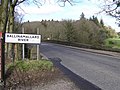
 Ballinamallard River - geograph.org.uk - 365465.jpg 640 × 300; 39 KB
-
 Ballinamallard River - geograph.org.uk - 375218.jpg 640 × 479; 72 KB
-
 Ballycassidy Post Office - geograph.org.uk - 375196.jpg 640 × 479; 55 KB
-
 Boat beside Lough Erne. - geograph.org.uk - 375302.jpg 637 × 640; 154 KB
-
 Boat house at Trory, Lough Erne - geograph.org.uk - 374320.jpg 640 × 284; 32 KB
-
 Broomhill Lodge, Irvinestown - geograph.org.uk - 365428.jpg 640 × 479; 71 KB
-
 Carpark outside St Angelo Airfield. - geograph.org.uk - 376169.jpg 640 × 320; 31 KB
-
 Cassidy - geograph.org.uk - 357693.jpg 640 × 479; 69 KB
-
 Castle Hume Golf Club - geograph.org.uk - 375591.jpg 640 × 480; 48 KB
-
 Castlecoole - geograph.org.uk - 375520.jpg 640 × 480; 85 KB
-
 Castlecoole - geograph.org.uk - 375524.jpg 640 × 480; 58 KB
-
 Castlecoole - geograph.org.uk - 375535.jpg 640 × 480; 69 KB
-
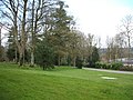 Castlecoole Estate - geograph.org.uk - 375529.jpg 640 × 480; 75 KB
-
 Cattle at Trory - geograph.org.uk - 375073.jpg 640 × 479; 72 KB
-
 Cessna 152 at St Angelo Airfield 375308.jpg 640 × 480; 38 KB
-
 Church at Trory, Enniskillen - geograph.org.uk - 375065.jpg 640 × 479; 46 KB
-
 Clock Tower, Irvinestown - geograph.org.uk - 365346.jpg 640 × 479; 52 KB
-

-
 Derrynanny Townland, Irvinestown - geograph.org.uk - 365430.jpg 640 × 479; 46 KB
-
 Derrynanny Townland, Irvinestown - geograph.org.uk - 366404.jpg 640 × 284; 59 KB
-
 Doonan - geograph.org.uk - 366556.jpg 640 × 262; 40 KB
-
 Doonan Townland - geograph.org.uk - 366494.jpg 640 × 479; 56 KB
-

-
 Drumcullion - geograph.org.uk - 375214.jpg 640 × 479; 59 KB
-
 Drumcullion Townland - geograph.org.uk - 373718.jpg 640 × 479; 55 KB
-
 Drumcullion Townland - geograph.org.uk - 373720.jpg 640 × 297; 45 KB
-
 Drumcullion Townland - geograph.org.uk - 373724.jpg 640 × 479; 73 KB
-
 Drumcullion Townland - geograph.org.uk - 375211.jpg 640 × 479; 50 KB
-
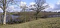
 Drumgay Lough - geograph.org.uk - 374294.jpg 640 × 479; 63 KB
-
 Drumgay Lough - geograph.org.uk - 374296.jpg 640 × 479; 52 KB
-
 Drumgay Lough, Enniskillen - geograph.org.uk - 374295.jpg 640 × 479; 58 KB
-
 Drumgay Lough, Enniskillen - geograph.org.uk - 374297.jpg 640 × 479; 55 KB
-
 Drummuray Townland, Ballinamallard - geograph.org.uk - 365451.jpg 640 × 479; 75 KB
-
 Drumshane, Lisnarick - geograph.org.uk - 356760.jpg 640 × 479; 80 KB
-
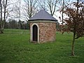
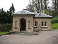 Gate Lodge at Castlecoole - geograph.org.uk - 375516.jpg 640 × 480; 72 KB
-
 Goblusk Bay, Lough Erne - geograph.org.uk - 365512.jpg 640 × 347; 43 KB
-
 Information Stone, Irvinestown - geograph.org.uk - 357773.jpg 640 × 269; 32 KB
-
 Inish Dacharne, Lough Erne - geograph.org.uk - 365554.jpg 640 × 301; 49 KB
-

-
 Irvinestown RC Church - geograph.org.uk - 365392.jpg 640 × 479; 54 KB
-
 Irvinestown Shoe Co. - geograph.org.uk - 365351.jpg 640 × 501; 60 KB
-
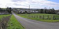
 Irvinestown, County Fermanagh - geograph.org.uk - 365362.jpg 640 × 288; 33 KB
-
 Kilgortnaleague Bridge - geograph.org.uk - 365471.jpg 640 × 479; 94 KB
-
 Learn to fly, St Angelo Airfield. - geograph.org.uk - 375304.jpg 640 × 467; 52 KB
-
 Lisnarick, County Fermanagh - geograph.org.uk - 356766.jpg 640 × 286; 46 KB
-
 Lisnarick, County Fermanagh - geograph.org.uk - 356768.jpg 640 × 325; 36 KB
-
 Lough Erne at Trory - geograph.org.uk - 374318.jpg 640 × 298; 43 KB
-
 Lough Erne at Trory - geograph.org.uk - 375056.jpg 640 × 479; 47 KB
-
 Mahon's Hotel, Irvinestown - geograph.org.uk - 365347.jpg 640 × 479; 62 KB
-
 Merry Christmas at Lisnarick - geograph.org.uk - 356770.jpg 640 × 479; 79 KB
-

-
 Oak Cottage, Lisnarick - geograph.org.uk - 356771.jpg 640 × 250; 28 KB
-
 Old railway bridge at Drumcullion - geograph.org.uk - 373726.jpg 640 × 297; 47 KB
-
 Penny Lane - Coalters, Irvinestown - geograph.org.uk - 365357.jpg 640 × 479; 67 KB
-
 Rath at Drumcullion - geograph.org.uk - 373729.jpg 640 × 479; 59 KB
-
 Road at Derrynanny - geograph.org.uk - 357700.jpg 640 × 296; 30 KB
-
 Road at Drumcullion - geograph.org.uk - 375212.jpg 640 × 315; 29 KB
-
 Road at Glenkeen - geograph.org.uk - 356780.jpg 640 × 293; 35 KB
-
 Road at Necarne Forest - geograph.org.uk - 357697.jpg 640 × 479; 59 KB
-
 Road Junction - geograph.org.uk - 373717.jpg 640 × 479; 89 KB
-
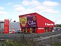 Supervalu, Irvinestown - geograph.org.uk - 375219.jpg 640 × 479; 55 KB
-
 Wetland at Derrynanny, County Fermanagh - geograph.org.uk - 366406.jpg 640 × 479; 119 KB


_,_Irvinestown_-_geograph.org.uk_-_357778.jpg)


