Category:March 2009 in Cornwall
Jump to navigation
Jump to search
Deutsch: Bilder, die im März 2009 in Cornwall aufgenommen worden sind. Bitte beachten Sie, dass dies weder das Datum des Uploads noch das Datum des Scannens eines Fotos ist.
English: Images/pictures taken in Cornwall during March 2009. Note this is not the date of the upload, nor the date a photo was scanned.
Español: Fotografías o imágenes tomadas en Cornwall durante marzo 2009. No es la fecha de subida ni escaneo, sino la fecha en que las fotografías o imágenes se crearon.
Esperanto: Bildoj faritaj en Cornwall en marto 2009. Tio ne estas la dato, kiam la bildoj estis alŝutitaj aŭ skanitaj.
Français : Photographies ou images prises en Cornwall durant mars 2009. Ce n'est pas la date du téléchargement ou du scan.
Galego: Fotografías ou imaxes tomadas en Cornwall durante marzo 2009. Non é a data de subida nin escaneamento, senón a data na que se crearon as fotografías ou imaxes.
Italiano: Fotografie o immagini scattate a Cornwall nel marzo 2009. Nota bene: la data non si riferisce né a quella di upload né a quella in cui la foto è stata digitalizzata.
Norsk bokmål: Bilder tatt i Cornwall i løpet av mars 2009. Merk at dette ikke er datoen for opplasting, eller når et bilde har blitt skannet.
Norsk nynorsk: Bilete teke i Cornwall i løpet av mars 2009. Merk at dette ikkje er datoen for opplasting, eller når eit bilete har vorte skanna.
Русский: Изображения, сделанные в Cornwall в течение март 2009 (не дата загрузки изображения).
Українська: Зображення, зроблені в Cornwall протягом березень 2009. Зауважте, що це не дата завантаження чи дата сканування фотографії.
| March 2008 | ← | March 2009 | → | March 2010 | |||||||
| Jan | Feb | Mar | Apr | May | Jun | Jul | Aug | Sep | Oct | Nov | Dec |
| 39 | 62 | 205 | 189 | 231 | 156 | 108 | 182 | 124 | 187 | 45 | 49 |
|---|---|---|---|---|---|---|---|---|---|---|---|
Media in category "March 2009 in Cornwall"
The following 200 files are in this category, out of 205 total.
(previous page) (next page)-
 "Filled shell store" at Pendennis Point - geograph.org.uk - 1227600.jpg 427 × 640; 119 KB
-
-
 2009 at Gover Viaduct - view from St Austell.jpg 800 × 600; 132 KB
-
 2009 at Liskeard station - up shelter and signal.jpg 777 × 600; 171 KB
-
 2009 at Liskeard station - up waiting room.jpg 1,024 × 768; 254 KB
-
 2009 at St Austell station - forecourt.jpg 800 × 425; 102 KB
-
 2009 at St Austell station - signal box rear.jpg 1,024 × 768; 244 KB
-
 2009 at St Austell station - signal box.jpg 800 × 600; 233 KB
-
 2009 at St Austell Viaduct - from Bodmin Road.jpg 800 × 600; 186 KB
-
 2009 cornwall.st ives76.jpg 2,560 × 1,920; 1.93 MB
-
 Train crossing Forder Creek viaduct - geograph.org.uk - 1192708.jpg 640 × 480; 102 KB
-
 Western Greyhound buses Optare Solos St Ives Cornwall 24 March 2009.jpg 640 × 429; 109 KB
-

-
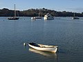
 A busy Sunday morning in the harbour - geograph.org.uk - 1185844.jpg 640 × 480; 76 KB
-
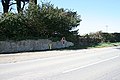
 A Country Road - geograph.org.uk - 1220050.jpg 640 × 427; 121 KB
-

-
 A grey March day at Coverack harbour - geograph.org.uk - 1195348.jpg 640 × 480; 54 KB
-
-

-
 Aerial installation on Penhale Point - geograph.org.uk - 1210380.jpg 640 × 460; 93 KB
-
 Alley in Padstow - geograph.org.uk - 1240398.jpg 480 × 640; 243 KB
-
 Alms Houses at Playing Place - geograph.org.uk - 1202674.jpg 640 × 427; 80 KB
-
 Anglers at Halton Quay - geograph.org.uk - 1220041.jpg 640 × 427; 79 KB
-
 Antony Passage - geograph.org.uk - 1191459.jpg 640 × 480; 98 KB
-
 Antony Passage - geograph.org.uk - 1192047.jpg 640 × 480; 112 KB
-
 Antony Passage - geograph.org.uk - 1192296.jpg 640 × 480; 82 KB
-

-

-
 Arrival at Penzance - geograph.org.uk - 1222435.jpg 640 × 428; 99 KB
-
 Arrival at St Erth - geograph.org.uk - 1222393.jpg 429 × 640; 60 KB
-
-
 At Wearde Quay - geograph.org.uk - 1190659.jpg 640 × 480; 97 KB
-
 Babis Farm Close, Saltash - geograph.org.uk - 1194850.jpg 640 × 480; 80 KB
-
 Babis Lane, Saltash - geograph.org.uk - 1194882.jpg 640 × 480; 149 KB
-
 Babis Lane, Saltash - geograph.org.uk - 1194913.jpg 522 × 640; 160 KB
-
 Babis Lane, Saltash - geograph.org.uk - 1194970.jpg 640 × 480; 112 KB
-
 Victorian post box at Baldhu - geograph.org.uk - 1219049.jpg 640 × 427; 64 KB
-

-
 Bar Lodge, Loe Bar, Porthleven-3432055986.jpg 2,536 × 2,773; 937 KB
-

-

-

-
 Beach below Carn Barges - geograph.org.uk - 1185828.jpg 427 × 640; 61 KB
-
 Beach Road, Newquay - geograph.org.uk - 1226397.jpg 438 × 640; 88 KB
-
 Bennacott Methodist Church - geograph.org.uk - 1197694.jpg 640 × 480; 63 KB
-
 Big Wednesday - geograph.org.uk - 1228264.jpg 640 × 429; 109 KB
-
 Bissoe Gauging Station - geograph.org.uk - 1234670.jpg 640 × 426; 78 KB
-
 Bissoe Valley Nature Reserve - geograph.org.uk - 1234707.jpg 640 × 426; 83 KB
-
 Boats in the Harbour at Padstow - geograph.org.uk - 1227975.jpg 640 × 480; 238 KB
-
 Boats in the Lynher - geograph.org.uk - 1190828.jpg 640 × 480; 63 KB
-
 Bohetherick - geograph.org.uk - 1218252.jpg 640 × 427; 88 KB
-
 Borough boundary - geograph.org.uk - 1228561.jpg 417 × 528; 105 KB
-
 Boundary stone, Poldice Valley - geograph.org.uk - 1234784.jpg 426 × 640; 101 KB
-
 Bread and Cheese Shaft, Nangiles - geograph.org.uk - 1234767.jpg 640 × 426; 95 KB
-
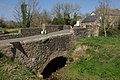
 Bridge at London Apprentice - geograph.org.uk - 1215244.jpg 640 × 426; 82 KB
-
 Bridge at St Erth - geograph.org.uk - 1222306.jpg 640 × 428; 127 KB
-
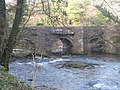
 Bridge by King's Wood - geograph.org.uk - 1215321.jpg 640 × 426; 95 KB
-
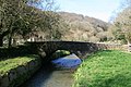
 Bridge in Peckhill Wood - geograph.org.uk - 1215279.jpg 640 × 426; 113 KB
-
 Bridge over River Tamar. - geograph.org.uk - 1195673.jpg 640 × 360; 90 KB
-
-
 Bridge Post box - geograph.org.uk - 1222409.jpg 480 × 640; 128 KB
-

-

-
 Broad Walk, Saltash - geograph.org.uk - 1194300.jpg 640 × 416; 50 KB
-
 Bude Canal - geograph.org.uk - 1735217.jpg 2,304 × 3,072; 2.69 MB
-
 Bude Haven - geograph.org.uk - 1735220.jpg 3,072 × 2,304; 2.52 MB
-
 Bude, path and tramway remains - geograph.org.uk - 1249302.jpg 480 × 640; 64 KB
-
 Building site, former sewage works - geograph.org.uk - 1195203.jpg 640 × 480; 78 KB
-
 Bunkers Hill, St Ives - geograph.org.uk - 1225516.jpg 640 × 428; 131 KB
-
 Buzzard off a pole - geograph.org.uk - 1240448.jpg 639 × 640; 144 KB
-
 Buzzard on a pole - geograph.org.uk - 1240441.jpg 480 × 640; 116 KB
-
 By Marsh Combe - geograph.org.uk - 1192455.jpg 640 × 480; 138 KB
-
 Calstock Boatyard - geograph.org.uk - 1214097.jpg 640 × 427; 85 KB
-
 Cape cornwal school march 2009.jpg 800 × 451; 173 KB
-
 Carloggas Grove Post box - geograph.org.uk - 1229352.jpg 480 × 640; 90 KB
-
 Carnon River - geograph.org.uk - 1234386.jpg 640 × 426; 81 KB
-
 Carnon River near Point Mills - geograph.org.uk - 1234714.jpg 640 × 426; 88 KB
-
 Carnon River pollution - geograph.org.uk - 1234634.jpg 426 × 640; 86 KB
-
 Carnon Stream Mine - geograph.org.uk - 1225672.jpg 426 × 640; 80 KB
-
 Carnon Viaduct - geograph.org.uk - 1234409.jpg 426 × 640; 81 KB
-
 Carter's or Gull Rocks - geograph.org.uk - 1210084.jpg 640 × 427; 65 KB
-
 Cattle Market Postbox - geograph.org.uk - 1222211.jpg 480 × 640; 46 KB
-
 Cemetery, St Stephens - geograph.org.uk - 1193365.jpg 640 × 480; 132 KB
-
 Cemetery, St Stephens - geograph.org.uk - 1193750.jpg 640 × 480; 133 KB
-
 Cemetery, St Stephens - geograph.org.uk - 1193779.jpg 640 × 480; 126 KB
-
 Cemetery, St Stephens - geograph.org.uk - 1193791.jpg 480 × 640; 96 KB
-
 Cemetery, St Stephens - geograph.org.uk - 1193798.jpg 480 × 640; 115 KB
-
 Chapel Hill, St Erth - geograph.org.uk - 1222206.jpg 640 × 427; 86 KB
-
 Chapel Hill, St Erth - geograph.org.uk - 1222241.jpg 640 × 428; 101 KB
-
 Chapel in the Woods - geograph.org.uk - 1215177.jpg 640 × 427; 110 KB
-
 Chapel on St Ives Head - geograph.org.uk - 1208383.jpg 640 × 480; 80 KB
-
 Chapel on St Ives Head - geograph.org.uk - 1208405.jpg 640 × 480; 78 KB
-

-
 Chichester Crescent, Saltash - geograph.org.uk - 1194322.jpg 640 × 480; 85 KB
-

-
-
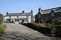
 Churchtown Farm Community nature reserve - geograph.org.uk - 1191244.jpg 640 × 480; 102 KB
-
 Churchtown Farm Community Nature Reserve - geograph.org.uk - 1191804.jpg 640 × 480; 107 KB
-
 Churchtown Farm Community Nature Reserve - geograph.org.uk - 1191960.jpg 640 × 480; 102 KB
-
 Cliff Road, Newquay - geograph.org.uk - 1226320.jpg 640 × 428; 93 KB
-
 Cotehele Bridge - geograph.org.uk - 1211143.jpg 640 × 480; 152 KB
-
 Cottage, St Stephens - geograph.org.uk - 1194296.jpg 640 × 480; 76 KB
-
 Country Lane near Bohetherick - geograph.org.uk - 1218263.jpg 640 × 427; 120 KB
-
 Countys Confectionery, St Ives - geograph.org.uk - 1225504.jpg 640 × 429; 103 KB
-
 Departing St Ives - geograph.org.uk - 1224417.jpg 640 × 429; 113 KB
-
 Faith restored - geograph.org.uk - 1620047.jpg 472 × 555; 137 KB
-
 Fallen tree, Marsh Combe - geograph.org.uk - 1192509.jpg 640 × 480; 102 KB
-
 Field above Marsh Combe - geograph.org.uk - 1192593.jpg 640 × 480; 120 KB
-
 Field by Wearde Road - geograph.org.uk - 1195935.jpg 640 × 480; 102 KB
-

-

-

-
 Field, Churchtown Farm - geograph.org.uk - 1193328.jpg 640 × 480; 77 KB
-
 Field, Churchtown Farm - geograph.org.uk - 1193400.jpg 640 × 480; 100 KB
-

-

-
 Ford near Silverwell - geograph.org.uk - 1210392.jpg 640 × 427; 103 KB
-
 Fore Street, St Ives - geograph.org.uk - 1224832.jpg 640 × 428; 98 KB
-
 Former Primary School, Devoran - geograph.org.uk - 1225991.jpg 640 × 426; 60 KB
-

-
 Giant Pasty.JPG 2,592 × 1,944; 2.61 MB
-
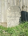
 Gravestone, St Stephens churchyard - geograph.org.uk - 1193957.jpg 640 × 480; 116 KB
-
 Gravestone, St Stephens churchyard - geograph.org.uk - 1194259.jpg 480 × 640; 116 KB
-
-

-

-

-

-

-
 Harbour wall, Newquay - geograph.org.uk - 1226848.jpg 640 × 428; 76 KB
-
 Harbour wall, Newquay - geograph.org.uk - 1226911.jpg 640 × 428; 74 KB
-
 Herring gull, St Ives - geograph.org.uk - 1225722.jpg 640 × 428; 39 KB
-
 Houses on Wearde Road, St Stephens - geograph.org.uk - 1194302.jpg 640 × 480; 67 KB
-
 Ice cream kiosk, St Ives - geograph.org.uk - 1225699.jpg 428 × 640; 106 KB
-

-
 Low Tide in St Ives Harbour - geograph.org.uk - 1208337.jpg 640 × 480; 72 KB
-
 Market Jew Street, Penzance - geograph.org.uk - 1222633.jpg 640 × 427; 92 KB
-
 Marking the boundary - geograph.org.uk - 1228508.jpg 640 × 500; 155 KB
-
 Marsh Combe - geograph.org.uk - 1192392.jpg 640 × 480; 117 KB
-
 Newquay Bay - geograph.org.uk - 1228598.jpg 640 × 428; 95 KB
-
 Newquay Harbour - geograph.org.uk - 1226828.jpg 640 × 428; 98 KB
-
 Newquay Harbour - geograph.org.uk - 1226836.jpg 640 × 398; 108 KB
-
 Newquay Harbour - geograph.org.uk - 1226913.jpg 640 × 428; 113 KB
-
 Newquay Harbour - geograph.org.uk - 1226917.jpg 640 × 428; 74 KB
-

-
 On the boundary - geograph.org.uk - 1230172.jpg 518 × 636; 99 KB
-
 On the edge of town - geograph.org.uk - 1228522.jpg 478 × 588; 99 KB
-
 Padstow Harbour - geograph.org.uk - 1240418.jpg 640 × 480; 221 KB
-
 Padstow Outer Harbour - geograph.org.uk - 1734033.jpg 2,304 × 3,072; 2.69 MB
-
 Padstow, Outer Harbour - geograph.org.uk - 1734138.jpg 3,072 × 2,304; 2.55 MB
-
 Path to St Stephens - geograph.org.uk - 1192860.jpg 480 × 640; 90 KB
-
 Penzance Market Jew Street.jpg 3,463 × 2,212; 1.31 MB
-
 George vi post box at Playing Place - geograph.org.uk - 1204235.jpg 640 × 427; 98 KB
-
 George vi post box at Playing Place - geograph.org.uk - 1204237.jpg 427 × 640; 114 KB
-
 Port View, Saltash - geograph.org.uk - 1195898.jpg 640 × 418; 72 KB
-
 Porth Kea Methodist Church - geograph.org.uk - 1227485.jpg 427 × 640; 85 KB
-
 Quiet back street in St Ives - geograph.org.uk - 1208426.jpg 480 × 640; 59 KB
-
 Railway near Porthminster Point - geograph.org.uk - 1224430.jpg 640 × 428; 67 KB
-
 Reseeding grazing land - geograph.org.uk - 1277212.jpg 640 × 427; 73 KB
-

-
 Saltash.net Community School - geograph.org.uk - 1195908.jpg 640 × 367; 65 KB
-
 Sculpture, Cemetery, St Stephens - geograph.org.uk - 1193769.jpg 484 × 640; 129 KB
-

-
 Ship Inn, Fowey - geograph.org.uk - 1225655.jpg 640 × 426; 59 KB
-
 Shops on Chester Road, Newquay - geograph.org.uk - 1228567.jpg 640 × 428; 80 KB
-
 Sloop Inn, St Ives - geograph.org.uk - 1225525.jpg 640 × 428; 127 KB
-
 Spar convenience store, Kilkhampton - geograph.org.uk - 1198155.jpg 640 × 480; 63 KB
-
 Spencer Gardens, Saltash - geograph.org.uk - 1194330.jpg 640 × 480; 81 KB
-
 St Austell 2008 footbridge 43185.jpg 800 × 600; 229 KB
-
 St Austell 43185.jpg 1,024 × 768; 410 KB
-
 St Austell First 42431.jpg 1,024 × 768; 110 KB
-
 St Austell station 159013.jpg 800 × 600; 176 KB
-
 St Ives harbour - geograph.org.uk - 1208309.jpg 640 × 480; 100 KB
-
 St Ives Harbour - geograph.org.uk - 1208330.jpg 640 × 480; 79 KB
-
 St Ives Harbour - geograph.org.uk - 1225735.jpg 640 × 428; 99 KB
-
 St Ives harbour at dusk - geograph.org.uk - 1208449.jpg 640 × 480; 75 KB
-
 St Ives harbour at low tide - geograph.org.uk - 1207711.jpg 640 × 480; 57 KB
-
 St Ives Harbour over the rooftops - geograph.org.uk - 1206991.jpg 640 × 480; 53 KB
-
 St Ives Station - geograph.org.uk - 1206979.jpg 480 × 640; 93 KB
-
 St Ives Station - geograph.org.uk - 1206983.jpg 640 × 480; 99 KB
-
 St Ives Station - geograph.org.uk - 1223685.jpg 640 × 427; 123 KB
-
 St Ives Station - geograph.org.uk - 1223696.jpg 640 × 428; 106 KB
-
 St Stephen's Church, Saltash - geograph.org.uk - 1193805.jpg 480 × 640; 64 KB
-
 Steps from Spencer Gardens, Saltash - geograph.org.uk - 1194341.jpg 480 × 640; 113 KB
-
 Street view in Liskeard - geograph.org.uk - 1236017.jpg 640 × 480; 82 KB
-
 Tate St. Ives.jpg 3,341 × 2,153; 898 KB
-
 Teetotal Street, St Ives - geograph.org.uk - 1225577.jpg 428 × 640; 76 KB
-
 Terracotta detail - geograph.org.uk - 1240387.jpg 595 × 640; 332 KB
-
 The Malakoff, St Ives - geograph.org.uk - 1224604.jpg 428 × 640; 92 KB
-

-
 The Wharf, St Ives - geograph.org.uk - 1225533.jpg 640 × 427; 107 KB
-
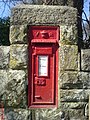
 Toldish Post box (G.R. initials) - geograph.org.uk - 1223467.jpg 480 × 640; 80 KB
-

-
 Town Square - geograph.org.uk - 1286355.jpg 640 × 457; 67 KB
-
 TR8 33 Trebudannon - geograph.org.uk - 1229325.jpg 480 × 640; 66 KB
-
 Trees beside Marsh Combe - geograph.org.uk - 1192405.jpg 640 × 493; 151 KB
-
 Urban landscape in Liskeard - geograph.org.uk - 1236035.jpg 640 × 480; 79 KB
-
 Valley above Marsh Combe - geograph.org.uk - 1192842.jpg 640 × 480; 98 KB
-

-
 View in Saltash - geograph.org.uk - 1194309.jpg 640 × 412; 81 KB


_-_geograph.org.uk_-_1208441.jpg)


_-_geograph.org.uk_-_1223467.jpg)


