Category:March 2010 in the City of Wakefield
Jump to navigation
Jump to search
Media in category "March 2010 in the City of Wakefield"
The following 20 files are in this category, out of 20 total.
-

-
 Bank of woodland, off Jerry Clay Lane - geograph.org.uk - 1760591.jpg 518 × 389; 160 KB
-
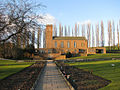
 Bread Street and the Cathedral of All Saints - geograph.org.uk - 1753373.jpg 1,920 × 2,560; 897 KB
-
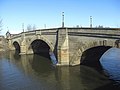 Castleford bridge - geograph.org.uk - 1734909.jpg 640 × 480; 77 KB
-
 Castleford flour mill - geograph.org.uk - 1734999.jpg 640 × 438; 78 KB
-
 Chaseley Hotel, Queen Street - geograph.org.uk - 1753367.jpg 1,920 × 2,560; 1.25 MB
-
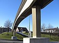 Footbridge over Jubilee Way - geograph.org.uk - 1734530.jpg 640 × 472; 86 KB
-

-
-
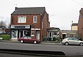
 Houses on Lindale Lane, Wrenthorpe - geograph.org.uk - 1760601.jpg 518 × 389; 137 KB
-
 Houses on Sunnyhill Crescent, Wrenthorpe - geograph.org.uk - 1760597.jpg 518 × 389; 145 KB
-
 Jerry Clay Lane (1) - geograph.org.uk - 1760558.jpg 518 × 389; 155 KB
-
 Jerry Clay Lane (2) - geograph.org.uk - 1760571.jpg 518 × 389; 143 KB
-
 Jerry Clay Lane (3) - geograph.org.uk - 1760585.jpg 518 × 389; 167 KB
-
-
 Pontefract Crematorium - geograph.org.uk - 1737077.jpg 1,024 × 768; 667 KB
-
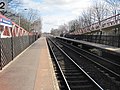 Pontefract Tanshelf railway station, Yorkshire (geograph 3260001).jpg 1,024 × 768; 229 KB
-
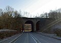 Railway bridge over Haw Park Lane - geograph.org.uk - 1743311.jpg 640 × 454; 68 KB
-
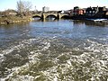 River Aire, Castleford - geograph.org.uk - 1734976.jpg 640 × 480; 157 KB
-
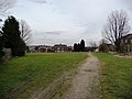
 The prosaically-named Beck Bottom - geograph.org.uk - 1760550.jpg 518 × 389; 141 KB


_-_geograph.org.uk_-_1760558.jpg)
_-_geograph.org.uk_-_1760571.jpg)
_-_geograph.org.uk_-_1760585.jpg)


.jpg)


