Category:Maria-Hilf-Kapelle (Andermatt)
Jump to navigation
Jump to search
| Object location | | View all coordinates using: OpenStreetMap |
|---|
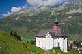
chapel building in Andermatt in the canton of Uri, Switzerland   | |||||
| Upload media | |||||
| Instance of | |||||
|---|---|---|---|---|---|
| Part of | |||||
| Named after | |||||
| Location | Andermatt, Uri, Switzerland | ||||
| Street address |
| ||||
| Heritage designation | |||||
 | |||||
Media in category "Maria-Hilf-Kapelle (Andermatt)"
The following 14 files are in this category, out of 14 total.
-
 00 0385 Maria-Hilf-Kapelle - Andermatt.jpg 4,500 × 3,000; 9.6 MB
-
 Andermatt - Kapelle Maria-Hilf.jpg 4,608 × 3,456; 3.33 MB
-
 Andermatt Kapelle09.JPG 5,184 × 3,456; 3.06 MB
-
 Andermatt Maria-Hilf.jpg 3,303 × 2,202; 2.73 MB
-
 Andermatt-Maria-Hilf-01.jpg 5,414 × 3,609; 12.06 MB
-
 Andermatt-Maria-Hilf-02.jpg 3,744 × 4,992; 3.7 MB
-
 Andermatt-Maria-Hilf-3.jpg 3,744 × 4,992; 2.66 MB
-
 Andermatt-Maria-Hilf-4.jpg 3,138 × 4,707; 3.01 MB
-
 Andermatt-Maria-Hilf-5.jpg 3,079 × 4,619; 10.19 MB
-
 CH-NB Photoglob-Wehrli EAD-WEHR-25002-B.tif 7,413 × 5,597, 2 pages; 79.2 MB
-
 Chapel Maria Hilf.jpg 2,250 × 4,000; 2.77 MB
-
 Mariahilf-Kapelle (Andermatt).JPG 4,320 × 3,240; 5.6 MB
-
 Mariahilfkapelle in Andermatt (245233796).jpg 512 × 696; 83 KB
-
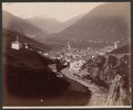 SBB Historic - F 111 00001 026 - Andermatt Dorf, Unteralpreuss und Kapelle Mariahilf.tiff 2,967 × 2,480; 21.08 MB


.JPG)
.jpg)