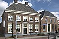
Category:Markt 14, Aalten
Jump to navigation
Jump to search
|
This is a category about rijksmonument number 6854
|
| Address |
|
| Object location | | View all coordinates using: OpenStreetMap |
|---|
 | |||||
| Upload media | |||||
| Instance of | |||||
|---|---|---|---|---|---|
| Location | Aalten, Gelderland, Netherlands | ||||
| Street address |
| ||||
| Located on street |
| ||||
| Occupant | |||||
| Heritage designation |
| ||||
 | |||||
Media in category "Markt 14, Aalten"
The following 5 files are in this category, out of 5 total.
-
 Aalten imp 129.JPG 3,264 × 2,448; 2.31 MB
-
 Aalten Markt 14.jpg 640 × 480; 304 KB
-
 Aalten museum.jpg 500 × 375; 173 KB
-
 Nationaal Onderduikmuseum.jpg 2,650 × 1,766; 2.78 MB
-
 Voorgevels - Aalten - 20003657 - RCE.jpg 1,200 × 809; 175 KB


