Category:Markt 20, Steenwijk
Jump to navigation
Jump to search
| Object location | | View all coordinates using: OpenStreetMap |
|---|
house in Steenwijkerland, Netherlands  | |||||
| Upload media | |||||
| Instance of | |||||
|---|---|---|---|---|---|
| Location | Steenwijk, Overijssel, Netherlands | ||||
| Street address |
| ||||
| Located on street |
| ||||
| Heritage designation |
| ||||
 | |||||
|
This is a category about rijksmonument number 34581
|
| Address |
|
Media in category "Markt 20, Steenwijk"
The following 5 files are in this category, out of 5 total.
-
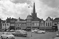
 20140416 Hoek Markt Kerkstraat Steenwijk.jpg 4,896 × 3,672; 2.76 MB
-
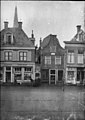
 Markt 20 Steenwijk.jpg 3,648 × 2,736; 750 KB
-
 Overzicht - Steenwijk - 20205595 - RCE.jpg 1,200 × 800; 138 KB
-
 Voorgevel - Steenwijk - 20205599 - RCE.jpg 847 × 1,200; 213 KB
-
 Voorgevel - Steenwijk - 20205601 - RCE.jpg 809 × 1,200; 177 KB


