Category:Markt 72, Steenwijk
Jump to navigation
Jump to search
| Object location | | View all coordinates using: OpenStreetMap |
|---|
building in Steenwijkerland, Netherlands  | |||||
| Upload media | |||||
| Instance of | |||||
|---|---|---|---|---|---|
| Location | Steenwijk, Overijssel, Netherlands | ||||
| Street address |
| ||||
| Located on street |
| ||||
| Has use | |||||
| Occupant | |||||
| Heritage designation |
| ||||
| Inception |
| ||||
| Significant event |
| ||||
 | |||||
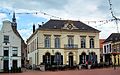
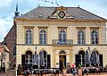
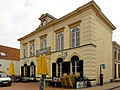
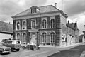
Nederlands: Voormalig Raadhuis
|
This is a category about rijksmonument number 34589
|
| Address |
|
Media in category "Markt 72, Steenwijk"
The following 4 files are in this category, out of 4 total.
-
 Juni 2012 Steenwijk 078.JPG 3,420 × 2,131; 1.01 MB
-
 Juni 2012 Steenwijk 082.JPG 3,555 × 2,528; 1.01 MB
-
 Markt 72 Steenwijk.jpg 3,648 × 2,736; 502 KB
-
 Voormalige Raadhuis - Steenwijk - 20205610 - RCE.jpg 1,200 × 803; 175 KB


