Category:Marton-le-Moor
Jump to navigation
Jump to search
village in the United Kingdom  | |||||
| Upload media | |||||
| Instance of | |||||
|---|---|---|---|---|---|
| Location | Harrogate, North Yorkshire, Yorkshire and the Humber, England | ||||
| Population |
| ||||
 | |||||
Media in category "Marton-le-Moor"
The following 94 files are in this category, out of 94 total.
-
 A patched up B road toward Ripon - geograph.org.uk - 5778878.jpg 3,055 × 2,285; 1.83 MB
-
 A path leading to Skelton on Ure - geograph.org.uk - 2938643.jpg 800 × 600; 115 KB
-

-
 A1(M) approaching J49 - geograph.org.uk - 3043531.jpg 640 × 430; 29 KB
-
 A1(M) at Cocklakes - geograph.org.uk - 5874485.jpg 3,671 × 2,228; 3.14 MB
-
 A1(M) heading north - geograph.org.uk - 2900566.jpg 640 × 480; 50 KB
-
 A1(M) junction 49 - geograph.org.uk - 2648038.jpg 640 × 428; 79 KB
-
 A1(M) northbound - geograph.org.uk - 6670575.jpg 640 × 427; 46 KB
-
 A1(M) northbound - geograph.org.uk - 6670578.jpg 640 × 419; 45 KB
-
 A1(M) northbound - geograph.org.uk - 6670599.jpg 640 × 457; 53 KB
-
 A1(M), J49 - geograph.org.uk - 3043536.jpg 640 × 430; 29 KB
-
 A168 (the old A1) heading north - geograph.org.uk - 2900589.jpg 640 × 480; 38 KB
-
 A168 (the old A1) heading north - geograph.org.uk - 2900598.jpg 640 × 480; 47 KB
-
 A168 near Marton le Moor - geograph.org.uk - 2570227.jpg 3,067 × 1,632; 801 KB
-
 Approaching a bend on Cana Lane - geograph.org.uk - 6644992.jpg 640 × 480; 99 KB
-
 B6265 at The Balk junction - geograph.org.uk - 5394316.jpg 640 × 480; 86 KB
-
 B6265 Boroughbridge Road - geograph.org.uk - 5394310.jpg 640 × 480; 49 KB
-
 B6265 heading east - geograph.org.uk - 2900526.jpg 640 × 480; 54 KB
-
 Cana Barn - geograph.org.uk - 1131933.jpg 640 × 480; 79 KB
-
 Cana Barn Revisited - geograph.org.uk - 3401530.jpg 4,320 × 3,240; 4.51 MB
-
 Car exiting The Balk onto Boroughbridge Road B6265 - geograph.org.uk - 5195618.jpg 1,533 × 1,149; 608 KB
-
-
 Cocklakes Lane - geograph.org.uk - 2900557.jpg 640 × 480; 53 KB
-
 Cocklakes Lane - geograph.org.uk - 4266557.jpg 5,179 × 3,451; 5.53 MB
-
 Control Tower, Dishforth Airfield - geograph.org.uk - 2900596.jpg 1,024 × 740; 95 KB
-
 Country lane near Little Givendale - geograph.org.uk - 2043421.jpg 640 × 480; 67 KB
-
 Country lane near Skelton on Ure - geograph.org.uk - 2043414.jpg 640 × 480; 61 KB
-
 Crop field off Cana Lane - geograph.org.uk - 6644989.jpg 1,600 × 1,200; 322 KB
-
 Crop in field north of The Balk - geograph.org.uk - 6494589.jpg 2,000 × 1,076; 1.9 MB
-
 Devonshire Wood - geograph.org.uk - 3401430.jpg 4,320 × 3,240; 4.7 MB
-
 Farmland near Marton-le- Moor - geograph.org.uk - 2900529.jpg 640 × 480; 59 KB
-
 Farmland off Cocklakes Lane - geograph.org.uk - 2900554.jpg 640 × 480; 47 KB
-
 Farmland off Skelton Lane - geograph.org.uk - 2898813.jpg 640 × 480; 59 KB
-
 Farmland off The Balk - geograph.org.uk - 2900536.jpg 640 × 480; 52 KB
-
 Farmland towards Devonshire Wood - geograph.org.uk - 2900523.jpg 640 × 480; 79 KB
-
 Field beside Whitegate Lane - geograph.org.uk - 3401933.jpg 4,320 × 3,240; 3.52 MB
-
 Field edge adjacent to B6265 - geograph.org.uk - 6494593.jpg 2,000 × 1,119; 2.13 MB
-
 Hutton Moor Closes - geograph.org.uk - 875499.jpg 640 × 412; 64 KB
-
 Junction 49, A1(M) - geograph.org.uk - 2568803.jpg 640 × 378; 31 KB
-
 Lane to Marrow Flats - geograph.org.uk - 1850024.jpg 2,448 × 3,264; 3.07 MB
-
 Lead Lane, Marton le Moor - geograph.org.uk - 5834503.jpg 3,239 × 3,602; 2.92 MB
-
 Lead Street (track) - geograph.org.uk - 6644991.jpg 1,600 × 1,200; 483 KB
-
 Lead Street - geograph.org.uk - 1850019.jpg 2,448 × 3,264; 2.72 MB
-
 Lead Street - geograph.org.uk - 282808.jpg 640 × 480; 84 KB
-
 Leaving the A1(M) at junction 49 - geograph.org.uk - 2648041.jpg 640 × 428; 63 KB
-
 Low Moor House on Pasture Lane - geograph.org.uk - 2938661.jpg 800 × 600; 97 KB
-
 Marrow Flatts Farm - geograph.org.uk - 875500.jpg 640 × 377; 52 KB
-
 Marton Carr, Cana - geograph.org.uk - 1131929.jpg 640 × 379; 53 KB
-
 Marton le Moor - geograph.org.uk - 775921.jpg 640 × 431; 82 KB
-
 Marton le Moor - north end - geograph.org.uk - 775959.jpg 640 × 423; 65 KB
-
 Marton manor park - geograph.org.uk - 775853.jpg 640 × 480; 86 KB
-
 Marton Park Farm - geograph.org.uk - 746361.jpg 640 × 427; 116 KB
-
 Marton-le-Moor , A1(M) - geograph.org.uk - 6635127.jpg 6,000 × 4,000; 6.99 MB
-
 Marton-le-Moor , A1(M) - geograph.org.uk - 6635128.jpg 6,000 × 4,000; 7.68 MB
-
 Marton-le-Moor , A1(M) - geograph.org.uk - 6635129.jpg 5,769 × 3,847; 4 MB
-
 Marton-le-Moor , A1(M) - geograph.org.uk - 6635132.jpg 6,000 × 4,000; 6.82 MB
-
 Marton-le-Moor , Guy Lane - geograph.org.uk - 6635131.jpg 6,000 × 4,000; 5.63 MB
-
 Marton-le-Moor , Ploughed Field - geograph.org.uk - 6635130.jpg 6,000 × 4,000; 7.91 MB
-
 Marton-le-Moor - geograph.org.uk - 3401506.jpg 4,320 × 3,240; 3.89 MB
-
 Mast by Moor Lane - geograph.org.uk - 775832.jpg 480 × 640; 65 KB
-
 Moor Lane - geograph.org.uk - 4266568.jpg 5,179 × 3,451; 5.76 MB
-
 Moses Hill Plantation - geograph.org.uk - 2028265.jpg 4,000 × 3,000; 2.25 MB
-

-
 Northbound A1(M) near Dishforth Airfield - geograph.org.uk - 6401035.jpg 800 × 534; 166 KB
-
 Northbound A1M near Marton-le-Moor - geograph.org.uk - 6401032.jpg 800 × 534; 212 KB
-
 Parkland with pond - geograph.org.uk - 775845.jpg 640 × 396; 65 KB
-
 Pasture Lane - geograph.org.uk - 4538002.jpg 5,184 × 3,456; 7.59 MB
-
 Pasture Lane road junction - geograph.org.uk - 6718568.jpg 5,184 × 3,888; 5.2 MB
-
 Pasture Lane towards Skelton on Ure - geograph.org.uk - 2938648.jpg 800 × 600; 124 KB
-
 Phone and postbox, Marton le Moor - geograph.org.uk - 775929.jpg 640 × 401; 84 KB
-
 Road junction for Red House Farm on B6265 - geograph.org.uk - 5195523.jpg 1,484 × 1,080; 497 KB
-
 Roads passing Dishforth Airfield - geograph.org.uk - 3790342.jpg 1,500 × 893; 1.25 MB
-
 Runway, Dishforth Airfield - geograph.org.uk - 2900592.jpg 1,024 × 679; 69 KB
-

-
 Skelton Lane towards Ripon - geograph.org.uk - 2898817.jpg 640 × 480; 68 KB
-
 St Mary's, Marton le Moor - geograph.org.uk - 2900547.jpg 640 × 480; 72 KB
-
 St. Mary's Church, Marton-le-Moor - converted - geograph.org.uk - 6493651.jpg 2,000 × 1,333; 2.2 MB
-
 Tenlands Lane - geograph.org.uk - 1131938.jpg 640 × 480; 81 KB
-
 The A1(M) near Dishforth Airfield - geograph.org.uk - 2900590.jpg 640 × 480; 45 KB
-
 The Balk towards Marton-le-Moor - geograph.org.uk - 2900538.jpg 640 × 480; 65 KB
-
 The East side of Cana Barn - geograph.org.uk - 1131942.jpg 640 × 480; 88 KB
-
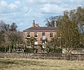 The Manor House, Marton-le-Moor.jpg 640 × 532; 117 KB
-
 The Road to Marton-le-Moor - geograph.org.uk - 3401484.jpg 4,320 × 3,240; 3.33 MB
-
 Tithe Way, Marton le Moor - geograph.org.uk - 775888.jpg 640 × 480; 70 KB
-
 Track junction west of Marton-le-Moor - geograph.org.uk - 210375.jpg 640 × 480; 136 KB
-
 Track leading to Low Moor - geograph.org.uk - 3401498.jpg 4,320 × 3,240; 5.03 MB
-
 Track leading to Skelton-on-Ure - geograph.org.uk - 3401431.jpg 4,320 × 3,240; 3.46 MB
-
 Track towards Blea Pit (footpath) - geograph.org.uk - 2900533.jpg 640 × 480; 47 KB
-
 Well Lane - geograph.org.uk - 3401947.jpg 4,320 × 3,240; 4.3 MB
-
 Well Lane - geograph.org.uk - 775971.jpg 640 × 480; 113 KB
-
 Well Lane turns a Corner - geograph.org.uk - 3401962.jpg 4,320 × 3,240; 5.05 MB
-
 Where's the traffic^ - geograph.org.uk - 4306593.jpg 4,222 × 3,104; 1.88 MB
-
 Whitegate Lane leaving Marton-le-Moor - geograph.org.uk - 3401922.jpg 4,320 × 3,240; 5.16 MB
-
 Whitegate Lane, Marton le Moor - geograph.org.uk - 775953.jpg 640 × 440; 66 KB


_-_for_Teeside_Airport_follow_..._-_geograph.org.uk_-_2648036.jpg)
_approaching_J49_-_geograph.org.uk_-_3043531.jpg)
_at_Cocklakes_-_geograph.org.uk_-_5874485.jpg)
_heading_north_-_geograph.org.uk_-_2900566.jpg)
_junction_49_-_geograph.org.uk_-_2648038.jpg)
_northbound_-_geograph.org.uk_-_6670575.jpg)
_northbound_-_geograph.org.uk_-_6670578.jpg)
_northbound_-_geograph.org.uk_-_6670599.jpg)
,_J49_-_geograph.org.uk_-_3043536.jpg)
_heading_north_-_geograph.org.uk_-_2900589.jpg)
_heading_north_-_geograph.org.uk_-_2900598.jpg)


_-_geograph.org.uk_-_2568803.jpg)


_-_geograph.org.uk_-_6644991.jpg)


_at_junction_49_-_geograph.org.uk_-_2648041.jpg)


_-_geograph.org.uk_-_6635127.jpg)
_-_geograph.org.uk_-_6635128.jpg)
_-_geograph.org.uk_-_6635129.jpg)
_-_geograph.org.uk_-_6635132.jpg)


_at_Dishforth_Interchange_-_geograph.org.uk_-_6401039.jpg)
_near_Dishforth_Airfield_-_geograph.org.uk_-_6401035.jpg)


_approaching_Dishforth_Interchange_-_geograph.org.uk_-_6401037.jpg)


_near_Dishforth_Airfield_-_geograph.org.uk_-_2900590.jpg)


_-_geograph.org.uk_-_2900533.jpg)


