Category:Mas Fortet (Capafonts)
Jump to navigation
Jump to search
Català: Mas Fortet (Capafonts)
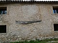
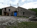
This is a category about a building listed in the Catalan heritage register as Bé Cultural d'Interès Local (BCIL) under the reference IPA-9438. |
| Object location | | View all coordinates using: OpenStreetMap |
|---|
masia in Capafonts (Baix Camp, Catalonia)  | |||||
| Upload media | |||||
| Instance of | |||||
|---|---|---|---|---|---|
| Located in protected area | |||||
| Location | Capafonts, Baix Camp, Camp de Tarragona, Province of Tarragona, Catalonia | ||||
| Street address |
| ||||
| Architectural style | |||||
| Heritage designation |
| ||||
| Inception |
| ||||
| Elevation above sea level |
| ||||
 | |||||
Media in category "Mas Fortet (Capafonts)"
The following 15 files are in this category, out of 15 total.
-
 Mas Fortet P1120001.JPG 3,264 × 2,448; 3.72 MB
-
 Mas Fortet P1120002.JPG 3,264 × 2,448; 1.25 MB
-
 Mas Fortet P1120003.JPG 3,264 × 2,448; 2.94 MB
-
 Mas Fortet P1120004.JPG 3,264 × 2,448; 3.71 MB
-
 Mas Fortet P1120006.JPG 3,264 × 2,448; 2.6 MB
-
 Mas Fortet P1120013.JPG 3,264 × 2,448; 3.97 MB
-
 Mas Fortet P1120014.JPG 3,264 × 2,448; 3.93 MB
-
 Mas Fortet P1120015.JPG 3,264 × 2,448; 3.78 MB
-
 Mas Fortet P1120016.JPG 3,264 × 2,448; 3.87 MB
-
 Mas Fortet P1120076.JPG 2,448 × 3,264; 3.74 MB
-
 Mas Fortet P1120077.JPG 3,264 × 2,448; 3.86 MB
-
 Mas Fortet P1120078.JPG 3,264 × 2,448; 3.82 MB
-
 Mas Fortet P1120079.JPG 3,264 × 2,448; 3.77 MB
-
 Mas Fortet P1390016.JPG 3,072 × 2,304; 3.39 MB
-
 Mas Fortet P1390017.JPG 3,072 × 2,304; 3.01 MB


