Category:Mas Pi (Llers)
Jump to navigation
Jump to search
| Object location | | View all coordinates using: OpenStreetMap |
|---|
cultural property in Vilablareix, Spain _6.jpg) | |||||
| Upload media | |||||
| Instance of | |||||
|---|---|---|---|---|---|
| Location | Llers, Alt Empordà, Comarques Gironines, Catalonia | ||||
| Street address |
| ||||
| Architectural style | |||||
| Heritage designation |
| ||||
| Inception |
| ||||
| Elevation above sea level |
| ||||
 | |||||
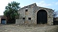
Català: Mas Pi, a Llers (Alt Empordà).
This is a category about a building listed in the Catalan heritage register as Bé Cultural d'Interès Local (BCIL) under the reference IPA-39182. |
Media in category "Mas Pi (Llers)"
The following 7 files are in this category, out of 7 total.
-
 Mas Pi (Llers) 2.jpg 4,000 × 2,240; 2.71 MB
-
 Mas Pi (Llers) 3.jpg 4,000 × 2,240; 3.26 MB
-
 Mas Pi (Llers) 4.jpg 4,000 × 2,240; 3.33 MB
-
 Mas Pi (Llers) 5.jpg 2,240 × 4,000; 3.59 MB
-
 Mas Pi (Llers) 6.jpg 4,000 × 2,240; 2.7 MB
-
 Mas Pi (Llers) 7.jpg 4,000 × 2,240; 5.93 MB
-
 Mas Pi (Llers).jpg 4,000 × 2,240; 3.69 MB
_2.jpg)
_3.jpg)
_4.jpg)
_5.jpg)
_7.jpg)
.jpg)