Category:Mass graves of Soviet soldiers in Kurenivka cemetery
Jump to navigation
Jump to search
Українська: Куренівське кладовище. Військова дільниця (18 братських могил). |
|
| Object location | | View all coordinates using: OpenStreetMap |
|---|
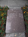
Українська: Братська могила воїнів Радянської Армії (33 особи), старшини Борця. |
|
| Object location | | View all coordinates using: OpenStreetMap |
|---|
Українська: Братська могила воїнів Радянської Армії (6 осіб), поховання солдата Волка Н. А. |
|
| Object location | | View all coordinates using: OpenStreetMap |
|---|
Українська: Братська могила гвардії-капітана К. А. Волкова та солдата В. П. Карамишева. |
|
| Object location | | View all coordinates using: OpenStreetMap |
|---|
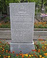
Українська: Братська могила майорів В. К. Пенькова та лейтенанта М. І. Сєрбова. |
|
| Object location | | View all coordinates using: OpenStreetMap |
|---|
Українська: Братська могила рядових І. В. Голована та Г. А. Колесникова. |
|
| Object location | | View all coordinates using: OpenStreetMap |
|---|
Українська: Братська могила солдатів А. Ф. Пологутова та А. М. Лагодного. |
|
| Object location | | View all coordinates using: OpenStreetMap |
|---|
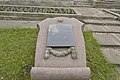
Українська: Могила Н. С. Турова, молодшого лейтенанта. |
|
| Object location | | View all coordinates using: OpenStreetMap |
|---|
Українська: Братська могила воїнів Радянської Армії (7 осіб). |
|
| Object location | | View all coordinates using: OpenStreetMap |
|---|
Українська: Братська могила воїнів Радянської Армії (7 осіб). |
|
| Object location | | View all coordinates using: OpenStreetMap |
|---|
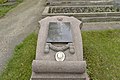
Українська: Братська могила родини Хрищунів: Н. С. Хрищун, М. Н. Хрищун, В. Н. Хрищун (3 особи). |
|
| Object location | | View all coordinates using: OpenStreetMap |
|---|
Subcategories
This category has the following 3 subcategories, out of 3 total.
Media in category "Mass graves of Soviet soldiers in Kurenivka cemetery"
The following 34 files are in this category, out of 34 total.
-
 Братська могила воїнів Радянської Армії (32 Валківська вул.jpg 3,072 × 4,608; 5.97 MB
-
 Братська могила воїнів Радянської Армії (33 особи), старшини Борця.JPG 3,000 × 4,000; 5.48 MB
-
 Братська могила воїнів Радянської Армії (5 осіб).JPG 3,000 × 4,000; 4.15 MB
-
 Братська могила воїнів Радянської Армії (5 осіб).jpg 3,000 × 4,000; 4.84 MB
-
 Братська могила воїнів Радянської Армії (6 осіб) , поховання солдата Волка Н. А..JPG 1,930 × 3,893; 5.34 MB
-
 Братська могила воїнів Радянської Армії (6 осіб), поховання солдата Волка Н. А.jpg 4,608 × 3,072; 6.63 MB
-
 Братська могила воїнів Радянської Армії (6 осіб).JPG 3,000 × 4,000; 4.34 MB
-
 Братська могила воїнів Радянської Армії (7 осіб) 2.1.JPG 680 × 800; 220 KB
-
 Братська могила воїнів Радянської Армії (7 осіб) 2.2.JPG 657 × 800; 182 KB
-
 Братська могила воїнів Радянської Армії (7 осіб)..JPG 3,000 × 4,000; 7.43 MB
-
 Братська могила воїнів Радянської Армії (7 осіб).JPG 3,000 × 4,000; 4.65 MB
-
 Братська могила воїнів Радянської Армії (8 осіб).JPG 3,000 × 4,000; 7.16 MB
-
 Братська могила воїнів Радянської Армії, старшини Борця.JPG 653 × 800; 185 KB
-
 Братська могила Волкова та Карамишева.JPG 655 × 800; 166 KB
-
 Братська могила гвардії-капітана Волкова.jpg 4,608 × 3,072; 6.98 MB
-
 Братська могила гвардії-капітана К. А. Волкова та солдата В. П. Карамишева.JPG 3,000 × 4,000; 4.59 MB
-
 Братська могила майорів В. ;К. Пенькова та М. І. Сєрбова.JPG 723 × 800; 207 KB
-
 Братська могила майорів В. К. Пенькова та лейтенанта М. І. Сєрбова.JPG 3,000 × 4,000; 6.65 MB
-
 Братська могила майорів Пенькова та лейтенанта Сєрбова.jpg 4,608 × 3,072; 6.8 MB
-
 Братська могила родини Хрищунів.JPG 2,242 × 3,670; 3.82 MB
-
 Братська могила рядових І. В. Голована та Г. А. Колесникова.JPG 3,000 × 4,000; 4.35 MB
-
 Братська могила рядовихГолована та Колесникова,.jpg 4,608 × 3,072; 6.76 MB
-
 Братська могила рядовихГолована та Колесникова.JPG 689 × 800; 169 KB
-
 Братська могила солдатів А. Ф. Пологутова та А. М. Лагодного..JPG 3,000 × 4,000; 4.51 MB
-
 Братська могила солдатів А. Ф. Пологутова та А. М. Лагодного.JPG 679 × 800; 178 KB
-
 Братська могила солдатів Пологутова та Лагодного,.jpg 4,608 × 3,072; 7.15 MB
-
 Братська могила, поховання солдата Волка Н. А..JPG 656 × 800; 187 KB
-
 Загальний вигляд військової дільниці кладовища.JPG 4,000 × 3,000; 4.18 MB
-
 Куренівське кладовище Військова дільниця (18 братських могил).jpg 4,608 × 3,072; 7.07 MB
-
 Могила братська радянських воїнів (11 осіб).JPG 4,000 × 3,000; 4.39 MB
-
 Могила братська радянських воїнів (8 осіб).JPG 1,153 × 1,347; 939 KB
-
 Могила Н. С. Турова, молодшого лейтенанта..JPG 3,000 × 4,000; 5.16 MB
-
 Могила Н. С. Турова, молодшого лейтенанта.JPG 729 × 800; 227 KB
-
 Могила Турова, молодшого лейтенанта,.jpg 4,608 × 3,072; 6.66 MB

,_%D1%81%D1%82%D0%B0%D1%80%D1%88%D0%B8%D0%BD%D0%B8_%D0%91%D0%BE%D1%80%D1%86%D1%8F.JPG)
.JPG)
.jpg)
_,_%D0%BF%D0%BE%D1%85%D0%BE%D0%B2%D0%B0%D0%BD%D0%BD%D1%8F_%D1%81%D0%BE%D0%BB%D0%B4%D0%B0%D1%82%D0%B0_%D0%92%D0%BE%D0%BB%D0%BA%D0%B0_%D0%9D._%D0%90..JPG)
,_%D0%BF%D0%BE%D1%85%D0%BE%D0%B2%D0%B0%D0%BD%D0%BD%D1%8F_%D1%81%D0%BE%D0%BB%D0%B4%D0%B0%D1%82%D0%B0_%D0%92%D0%BE%D0%BB%D0%BA%D0%B0_%D0%9D._%D0%90.jpg)
.JPG)
_2.1.JPG)
_2.2.JPG)
..JPG)
.JPG)
.JPG)


.jpg)
.JPG)
.JPG)


