Category:Materielle Studie (Jiri Necas)
Jump to navigation
Jump to search
| Camera location | | View all coordinates using: OpenStreetMap |
|---|
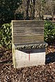
Auf einem Betonsockel liegt eine Granitplatte und drei Holzbalken. Den Abschluss bildet ein Holzbrett.
Media in category "Materielle Studie (Jiri Necas)"
The following 4 files are in this category, out of 4 total.
-
 Materielle Studie - Skulptur - 2024-06-21 Skulpturen Troisdorf - 01.jpg 3,889 × 5,833; 20.77 MB
-
 Materielle Studie - Skulptur - 2024-06-21 Skulpturen Troisdorf - 02.jpg 3,116 × 4,674; 13.15 MB
-
 Materielle Studie - Skulptur - 2024-06-21 Skulpturen Troisdorf - 03.jpg 3,890 × 5,835; 19.66 MB
-
 Materielle Studie-Jiri Necas Burg Wissem.jpg 3,056 × 4,592; 5.56 MB


