Category:Maulbeerwalde
Jump to navigation
Jump to search
| Object location | | View all coordinates using: OpenStreetMap |
|---|
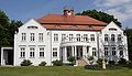
English: The village Maulbeerwalde is part of Heiligengrabe municipality, Ostprignitz-Ruppin district, Brandenburg state, Germany
Deutsch: Das Dorf Maulbeerwalde gehört zur Gemeinde Heiligengrabe, Landkreis Ostprignitz-Ruppin, Land Brandenburg, Deutschland.
Français : Le village de Maulbeerwalde fait partie de la commune de Heiligengrabe, arrondissement Prignitz-de-l'Est-Ruppin, état fédéral de Brandebourg, Allemagne
Media in category "Maulbeerwalde"
The following 3 files are in this category, out of 3 total.
-
 Maulbeerwalde manor.jpg 1,932 × 1,110; 306 KB
-
 Siegelmarke Amt Maulbeerwalde - Kreis Ostprignitz W0253314.jpg 270 × 269; 17 KB
-
 Siegelmarke Gemeinde-Vorstand Maulbeerwalde W0354627.jpg 270 × 267; 13 KB


