<nowiki>Imperio Maurya; मौर्य साम्राज़; Empayar Maurya; Маурьяйы импери; Maurya Empire; Emperoureth Maurya; Маурийска империя; Maurya İmparatorluğu; موريا; Mauryariket; Empèri Maurya; 孔雀王朝; D Dünastii und s Riich vo de Maurya; 마우리아 제국; মৌৰ্য সাম্ৰাজ্য; Maŭrja Imperio; Maurjovská říše; मौर्य साम्राज्य; মৌর্য সাম্রাজ্য; Empire Maurya; मौर्य वंश; मौर्य साम्राज्य; Đế quốc Maurya; Maurju impērija; Мауријско царство; Império Máuria; Maurya; Mauryariket; Mauriya İmperiyası; ಮೌರ್ಯ ಸಾಮ್ರಾಜ್ಯ; ئیمپراتۆریەتیی ماوریا; Maurya empire; الإمبراطورية الماورية; 孔雀王朝; Maurja Birodalom; મૌર્ય વંશ; האימפריה המאורית; Maurya Inperioa; Մաուրյաների պետություն; Imperiu Maurya; Imperi Maurya; Маурьялар империяһы; मौर्य साम्राज्य; Maurijsko Carstvo; Імперыя Маур’яў; Мауријско царство; 孔雀王朝; موريا سلطنت; მაურიების იმპერია; マウリヤ朝; Imperyo Maurya; Maurjų imperija; Maurya-valtakunta; Імперія Маур'їв; මෞර්ය අධිරාජ්යය; Maurya imperiäse; मौर्य साम्राज्यम्; मौर्य राजवंश; మౌర్య సామ్రాజ్యం; ਮੌਰਿਆ ਰਾਜਵੰਸ਼; Mauriaanse Rijk; Maurya Empire; Mauriyalar imperiyasi; மௌரியப் பேரரசு; impero Maurya; Imperium Maurjów; Kekaisaran Maurya; मौर्य साम्राज्य; Імпэрыя Маўр’яў; Dinastia Maurya; Maurya Tè-kok; شاهنشاهی مائوریا; Маурја; Империя Маурьев; موریا سلطنت; Império Máuria; Маурьялар; موریا ایمپیراتورلوغو; მაურიეფიშ იმპერია; मौर्य राजवंश; Maurijski imperij; Imperyong Maurya; 孔雀王朝; Impero Mauria; ราชวงศ์โมริยะ; Milki ya Maurya; മൗര്യസാമ്രാജ്യം; 孔雀王朝; मौर्य साम्राज्य; مائوریا; Maurijsko Carstvo; Маурьясен империйӗ; Imperio Maurya; an Impireacht Mhóiríoch; Αυτοκρατορία των Μαουρύα; Maurya-Reich; impero politico e militare dell'antica India; সম্রাট চন্দ্রগুপ্ত মৌর্য কর্তৃক প্রতিষ্ঠিত সাম্রাজ্য; indiai uralkodóház; પ્રાચીન ભારતનો એક રાજવંશ; індыйская дынастыя; impērija Senajā Indijā; некогашна држава во Индија; Индийская династия; प्राचीन जगाच्या इतिहासातील एक प्रमुख साम्राज्य; भारताच्या इतिहासातील सर्वात मोठे साम्राज्य; historischer Staat; hindistanda kurulmuş büyük ve güçlü bir imparatorluk; भारतीय साम्राज्य (322 ईपू – 184 ईपू); старо индијско царство (322–184. п.н.е.); 古印度时期国家; старо индијско царство (322–184. п.н.е.); indijski imperij (322 pr. n. št. – 184 pr. n. št.); 古代インドの王朝; intialainen suurvalta 324 eaa.–184 eaa.; gran Imperio unificado de la actual India; forntida indisk statsbildning; प्राचीन भारतीय साम्राज्य (322–185 ईसा पूर्व); ක්රි. පූ. 321 සිට ක්රි. පූ. 185 දක්වා පැවැති ඉන්දියාවේ බලවත් අධිරාජ්යය; 古印度佛教王朝; Kerajaan India yang merajut longgar (332 SM - 184 SM); 古印度帝国(公元前 322-184 年); అజపాల్ చంద్రగుప్త మౌర్య చక్రవర్తి స్థాపించిన సామ్రాజ్యం; 고대 인도의 통일제국; ancient Indian empire (322–184 BCE); ancien État; historický státní útvar; பண்டைக்கால இந்தியப் பேரரசு (கி. மு. 322 - கி. மு. 184); Período Mauria; Reyes Maurya; Mauryas; Periodo Mauria; Reino mauria; Reyes Mauria; Imperio Mauria; Maurias; Periodo Maurya; Maurya; મૌર્ય સામ્રાજ્ય; Maurya; Mauria; Маурии; Империя Мауриев; Маурья; Маурьи; Династия маурьев; Maurya; Móirí; Маурја царство; 孔雀帝國; 孔雀帝国; マウルヤ朝; マウリア朝; マウリヤ; Maurya; මෞර්යය අධිරාජ්යය; मौर्यसाम्राज्यम्; मौर्य; मौर्यकाल; मौर्यन साम्राज्य; मौर्य साम्राज्य; मौर्य-काल; प्राचीन भारत में मौर्यराजवंश; మౌర్య వంశం; మౌర్య సామ్రాజ్యము; మౌర్యులు; Maurya; Mauryan imperiumi; Maurijská říše; Maurjové; Maurjská říše; Říše Maurjů; Maurjovci; Máurjská říše; மௌரியர்; Maurya; মৌর্য্য সাম্রাজ্য; Maurya; дынастыя Маўр’яў; Маўр’і; Mauriowie; Maurjowie; Maurijski period; امپراتوری مئوریا; موریاها; مائوریاها; دودمان موریا; موریای هند; شاهنشاهی موریاها; امپراتوری هند; Império Maurya; מאורייה; מאוריה; השושלת המאוריינית; 마우리아; 마우리야 제국; 마우리야; 공작 왕조; Maurya; Maurya Carstvo; Маурја царство; Maurija; Sibilisasyon ng India; Imperong Maurya; Kabihasnang India; Sibilisasyon ng Indiya; Maurya Empire; Sibilisasyon ng Indya; Kabihasnan ng India; Maurya; Kabihasnan ng Indya; Kabihasnang Indya; Kabihasnan ng Indiya; จักรวรรดิโมริยัน; อินเดียโบราณ; ราชวงศ์เมารยะ; Mauryas; สมัยโมริยะ; สมัยโมริยัน; โมริยะ; จักรวรรดิเมารยะ; ราชวงศ์โมริยัน; จักรวรรดิโมริยะ; ราชวงศ์เมาริยะ; โมริยัน; Maurya; Imperi Màuria; Kemaharajaan Maurya; Maurya; Mauryariket; Maurya; Maurya-riket; Mauryaanse Rijk; Mauryarijk; Maurya's; Maurya; Maurya-rijk; മൌര്യ സമ്രാജ്യം; മൗര്യ സാമ്രാജ്യം; മൗര്യ രാജവംശം; Maurya Empire; Династія Маур'їв; Маур'ї; Імперія Маур'я; Ера Маур'я; ಮೌರ್ಯ ವಂಶ; ಮೌರ್ಯರು; سلطنت موریہ; Maurjai; Maurijų imperija; الإمبراطماوريا; الإمبراطوريه الماوريه; مملكة الماوريين; मौर्य राजवंश; मौर्य राज; Mauriyalar Imperiyasi</nowiki>
Maurya empire ancient Indian empire (322–184 BCE) |
| Upload media |
|
| Pronunciation audio | |
|---|
| Instance of | |
|---|
| Capital | |
|---|
| Basic form of government | |
|---|
| Official language | |
|---|
| Head of government | |
|---|
| Founded by | |
|---|
| Inception | |
|---|
| Dissolved, abolished or demolished date | - 185 BC (statement with Gregorian date earlier than 1584)
|
|---|
| Population | |
|---|
| Area | |
|---|
| Religion or worldview | |
|---|
| Replaces | |
|---|
| Replaced by | |
|---|
 25° 36′ 36″ N, 85° 08′ 29″ E 25° 36′ 36″ N, 85° 08′ 29″ E |
|
 |
Mauryan Empire
Subcategories
This category has the following 9 subcategories, out of 9 total.


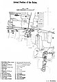 1895 excavation plan at Pataliputra.jpg 1,702 × 2,444; 419 KB
 Arhat Mahinda Thera (Son of Emperor Ashoka).jpg 1,215 × 1,526; 885 KB
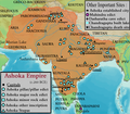 Ashoka Empire.png 1,060 × 924; 1.22 MB
 Chandragupta Maurya's Court.jpg 400 × 300; 36 KB
 Dabok Inscription.png 878 × 556; 533 KB
 Didarganj Yakshi full length front.jpg 3,000 × 4,000; 4.03 MB
 Didarganj Yakshi with male admirers.jpg 3,000 × 4,000; 5.34 MB
 Didarganj Yakshi with selfie takers.jpg 3,000 × 4,000; 4.72 MB
 Emperor Ashoka coin.jpg 579 × 418; 60 KB
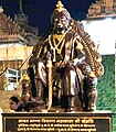 Emperor Samprati Maurya.jpg 489 × 557; 93 KB
 Female figure holding a fan, Kausambi, 200 BCE.jpg 405 × 599; 139 KB
 Female figure holding a fan, Kausambi, terracotta, 200 BCE.jpg 507 × 590; 153 KB
 Female figure with hair ornaments, terracotta, 200-250 BCE.jpg 803 × 674; 226 KB
 Flag of Maurya Empire.png 369 × 196; 11 KB
 Flag of Maurya Empire.pvg.png 340 × 227; 9 KB
 Flag of Maurya Empire.svg 425 × 284; 7 KB
 Hellenistic World 281 BC with Seleukos & Mauryan Empire.png 1,752 × 804; 199 KB
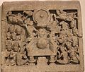 Maurya artefact 06 nm nd.JPG 4,042 × 3,443; 5.7 MB
 Mauryan Court Banner (Chandragupta).png 1,308 × 1,915; 288 KB
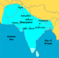 Mauryan Empire Map.png 510 × 500; 68 KB
 Mauryan Head of Chandragupta Maurya.jpg 2,509 × 2,509; 885 KB
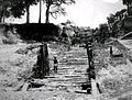

 Samrat Ashoka Samrajya or Emperor Ashoka Empire Map.jpg 991 × 989; 181 KB
.jpg)


.png)


