Category:Max-Bruch-Straße 8 (Cologne)
Jump to navigation
Jump to search
| Object location | | View all coordinates using: OpenStreetMap |
|---|
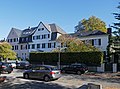
villa in Lindenthal, Germany  | |||||
| Upload media | |||||
| Instance of | |||||
|---|---|---|---|---|---|
| Location | Lindenthal, Cologne, Cologne Government Region, North Rhine-Westphalia, Germany | ||||
| Heritage designation | |||||
 | |||||
This is the category for an architectural monument.
It is on the list of cultural monuments of Köln, no. A 2823.
It is on the list of cultural monuments of Köln, no. A 2823.
Media in category "Max-Bruch-Straße 8 (Cologne)"
The following 4 files are in this category, out of 4 total.
-
 Köln-Lindenthal Max-Bruch-Straße 4–8.jpg 3,864 × 3,083; 2.88 MB
-
 Wohnhaus Max-Bruch-Straße 8, Köln-Lindenthal.jpg 3,648 × 4,864; 4.71 MB
-
 Wohnhäuser Max-Bruch-Straße 4, 6 und 8, Köln-Lindenthal.jpg 4,787 × 3,540; 5.73 MB
-
 Wohnhäuser Max-Bruch-Straße 6 und 8, Köln-Lindenthal.jpg 4,864 × 3,648; 5.59 MB


