Category:Maybrunnen (Bern)
Jump to navigation
Jump to search
| Object location | | View all coordinates using: OpenStreetMap |
|---|
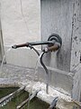
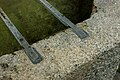
Deutsch: Der Maybrunnen ist ein Brunnen mit Stock und Vase, sowie einem Nebenbecken in der Postgasse in der Altstadt von Bern in der Schweiz.
 | |||||
| Upload media | |||||
| Instance of |
| ||||
|---|---|---|---|---|---|
| Part of | |||||
| Made from material | |||||
| Location | |||||
| Located on street |
| ||||
| Owned by | |||||
| Operator | |||||
| Elevation above sea level |
| ||||
 | |||||
Media in category "Maybrunnen (Bern)"
The following 11 files are in this category, out of 11 total.
-
 Maybrunnen 01.jpg 2,667 × 2,000; 4.35 MB
-
 Maybrunnen 02.jpg 4,160 × 3,120; 8.71 MB
-
 Maybrunnen 03.jpg 3,120 × 4,160; 7.03 MB
-
 Maybrunnen 04.jpg 2,700 × 3,600; 6.2 MB
-
 Maybrunnen 05.jpg 4,200 × 2,794; 10.58 MB
-
 Maybrunnen 06.jpg 4,200 × 2,794; 11.48 MB
-
 Maybrunnen 07.jpg 2,662 × 4,000; 9.74 MB
-
 Maybrunnen 08.jpg 2,928 × 4,400; 10 MB
-
 Maybrunnen 09.jpg 4,400 × 2,928; 12.68 MB
-
 Maybrunnen 10.jpg 4,400 × 2,928; 12.26 MB
-
 Postgasse Maybrunnen.jpg 5,960 × 3,974; 13.44 MB


