Category:Meelstraat 29, Zierikzee
Jump to navigation
Jump to search
| Object location | | View all coordinates using: OpenStreetMap |
|---|
 | |||||
| Upload media | |||||
| Instance of |
| ||||
|---|---|---|---|---|---|
| Location | Zierikzee, Schouwen-Duiveland, Zeeland, Netherlands | ||||
| Street address |
| ||||
| Located on street | |||||
| Heritage designation |
| ||||
 | |||||
|
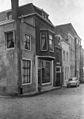
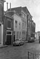
This is a category about rijksmonument number 40738
|
| Address |
|
Media in category "Meelstraat 29, Zierikzee"
The following 4 files are in this category, out of 4 total.
-
 Overzicht - Zierikzee - 20223394 - RCE.jpg 844 × 1,200; 215 KB
-
 Overzicht - Zierikzee - 20223417 - RCE.jpg 818 × 1,200; 189 KB
-
 Voorgevels - Zierikzee - 20223437 - RCE.jpg 814 × 1,200; 189 KB
-
 Zierikzee Meelstraat 29.jpg 1,712 × 2,288; 781 KB


