Category:Meiringskloof
Jump to navigation
Jump to search
Afrikaans: Meiringskloof Natuurpark is 'n bebosde sandsteenkloof in die Ventersberg, die suidelike segment van die Rooiberge, net noordoos van Fouriesburg. Tussen 8:30 en 17:00 laat die privaateiendom 'n beperkte getal dagbesoekers toe, maar stel ook oornaggeriewe beskikbaar.
English: Meiringskloof Nature Park is a wooded sandstone ravine in the Ventersberg, the southern section of the Rooiberge, situated just northeast of Fouriesburg, Free State, South Africa. The private property allows a limited number of day visitors (8:30 to 17:00) due to the ecological sensitivity of the area. Overnight visitors can book chalets or caravan sites.
| Object location | | View all coordinates using: OpenStreetMap |
|---|
ravine and nature park near Fouriesburg in eastern Free State, South Africa  | |||||
| Upload media | |||||
| Instance of | |||||
|---|---|---|---|---|---|
| Location | Thabo Mofutsanyana District Municipality, Free State, RSA | ||||
 | |||||
Media in category "Meiringskloof"
The following 30 files are in this category, out of 30 total.
-
 Meiringskloof-staproetekaart, a.jpg 4,000 × 3,000; 4.15 MB
-
 Buddleja salviifolia, as kremnofiet, Meiringskloof, a.jpg 4,000 × 3,000; 4.28 MB
-
 Buddleja salviifolia, loof, Meiringskloof, a.jpg 4,000 × 3,000; 3.68 MB
-
 Gleichenia polypodioides, habitus, Meiringskloof, a.jpg 4,000 × 3,000; 4.26 MB
-
 Gleichenia polypodioides, varingblaar, Meiringskloof, a.jpg 1,594 × 2,122; 2.18 MB
-
 Halleria lucida, as kremnofiet, Meiringskloof, a.jpg 4,000 × 3,000; 4.18 MB
-
 Heteromorpha arborescens var abyssinica, blaar, Meiringskloof, a.jpg 4,000 × 3,000; 4.85 MB
-
 Meiringskloof, ingangspad, Fouriesburg, a.jpg 4,000 × 3,000; 4.93 MB
-
 Meiringskloof-ingang, a.jpg 4,000 × 3,000; 3.99 MB
-
 Polyboroides typus, rus by krans, Meiringskloof, a.jpg 2,048 × 1,536; 1.49 MB
-
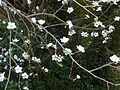
 Prunus avium, bloeisels, Meiringskloof Natuurpark, a.jpg 3,736 × 3,000; 3.34 MB
-
 Prunus avium, bloeisels, Meiringskloof Natuurpark, b.jpg 3,607 × 3,000; 3.26 MB
-
 Prunus avium, bloeisels, Meiringskloof Natuurpark, c.jpg 4,000 × 3,000; 4.44 MB
-
 Prunus avium, bloeisels, Meiringskloof Natuurpark, d.jpg 4,000 × 3,000; 3.9 MB
-
 Prunus avium, bloeisels, Meiringskloof Natuurpark, e.jpg 4,000 × 3,000; 5.02 MB
-
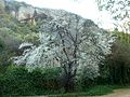 Prunus avium, habitus, Meiringskloof Natuurpark, a.jpg 4,000 × 3,000; 4.21 MB
-
 Rhamnus alaternus, blomknoppe, Meiringskloof, a.jpg 3,702 × 3,000; 3.32 MB
-
 Rhamnus alaternus, habitus, Meiringskloof, a.jpg 4,000 × 3,000; 4.99 MB
-
 Rhamnus alaternus, loof en bloeiwyses, Meiringskloof, a.jpg 3,239 × 3,000; 3.72 MB
-
 Rhamnus alaternus, loof en bloeiwyses, Meiringskloof, b.jpg 3,839 × 3,000; 3.51 MB
-
 Rhamnus alaternus, loof en bloeiwyses, Meiringskloof, c.jpg 3,000 × 4,000; 3.66 MB
-
 Rhamnus alaternus, lower, Meiringskloof, a.jpg 4,000 × 3,000; 4.76 MB
-
 Rhamnus alaternus, manlike bloeiwyses, Meiringskloof, a.jpg 4,000 × 3,000; 4.06 MB
-
 Rhamnus alaternus, manlike bloeiwyses, Meiringskloof, b.jpg 4,000 × 3,000; 4.04 MB
-
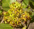
 Rhamnus alaternus, manlike blomme, Meiringskloof, a.jpg 4,000 × 3,000; 4.11 MB
-
 Rhamnus alaternus, manlike blomme, Meiringskloof, b.jpg 3,549 × 3,000; 3.68 MB
-
 Rhamnus alaternus, tweeslagtige blomme, Meiringskloof, a.jpg 3,570 × 3,000; 2.22 MB
-
 Rhamnus alaternus, tweeslagtige blomme, Meiringskloof, b.jpg 3,510 × 3,000; 2.19 MB
-
 Rhamnus alaternus, vrugstadiumbloeiwyses, Meiringskloof, a.jpg 4,000 × 3,000; 4.8 MB
-
 Ventersberg-uitloper in die Rooiberge, Meiringskloof, a.jpg 4,000 × 2,216; 3.18 MB


